IMAGES TAKEN NEAR TO
Temple Sowerby, PENRITH, CA10 1SA
Introduction
This page details the photographs taken nearby to CA10 1SA by members of the Geograph project.
The Geograph project started in 2005 with the aim of publishing, organising and preserving representative images for every square kilometre of Great Britain, Ireland and the Isle of Man.

There are currently over 7.5m images from over14,400 individuals and you can help contribute to the project by visiting https://www.geograph.org.uk
Image Map
Images are licensed for reuse under creativecommons.org/licenses/by-sa/2.0
Notes
- Clicking on the map will re-center to the selected point.
- The higher the marker number, the further away the image location is from the centre of the postcode.
Image Listing (44 Images Found)
Images are licensed for reuse under creativecommons.org/licenses/by-sa/2.0
Image
Details
Distance
1
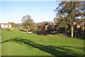
Football ground on the village green, Temple Sowerby
Sometimes the ball must go careering off down the road!
Image: © Humphrey Bolton
Taken: 2 Nov 2006
0.02 miles
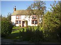
2
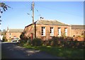
The Counting House, Temple Sowerby
Perhaps formerly an estate office, where rents were collected?
Image: © Humphrey Bolton
Taken: 2 Nov 2006
0.02 miles
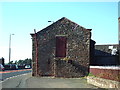
3
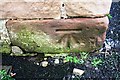
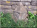
Benchmark on barn at West View Farm
Ordnance Survey cut mark benchmark described on the Bench Mark Database at www.bench-marks.org.uk/bm59072
Image: © Luke Shaw
Taken: 4 Feb 2020
0.05 miles
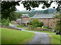
4
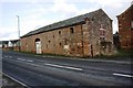
Barn at West View Farm
There is an OS benchmark Image on the near corner, road face, of the building
Image: © Luke Shaw
Taken: 4 Feb 2020
0.05 miles
5
Rose Bank, Temple Sowerby
A cottage of the type with little space between ground-floor and first-floor windows, the latter must be at floor level.
Image: © Humphrey Bolton
Taken: 2 Nov 2006
0.05 miles
6
Road side Barn
Situated on the outskirts of Temple Sowerby on the side of the A66 it is not now used as such because of the busy A66
Image: © Alexander P Kapp
Taken: 8 Sep 2006
0.05 miles
7
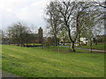
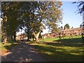
Temple Sowerby village green, Cumbria
This shows the village green, children's swings and slide, and St James Church. For a much better view of Temple Sowerby, which is the principal feature within this OS grid square, please see the 'supplemental' image.
Image: © Simon Ledingham
Taken: 17 Apr 2004
0.07 miles
8
Dovecote at Temple Sowerby
Viewed from The Green.
Image: © Russel Wills
Taken: 8 Jul 2014
0.09 miles
9
Old Milepost north of Temple Sowerby
Cast iron post by the former A66, in parish of Temple Sowerby (Eden District), opposite large farm yard (West View) on North West edge of village, on grass against stone wall, on North East side of road. Appleby plate, erected by the Brough & Eamont Bridge turnpike trust in the 19th century.
Inscription reads:-
: APPLEBY / 7 / MILES : : PENRITH / 6 / MILES :
Milestone Society National ID: WE_PRAP06
Image: © CF Smith
Taken: 6 Dec 2009
0.10 miles
10
Road across the green, Temple Sowerby
This road forms the spine of the village, and is quite narrow. The swings are made of timber rather than the brightly painted metal found in towns.
Image: © Humphrey Bolton
Taken: 2 Nov 2006
0.10 miles