IMAGES TAKEN NEAR TO
Low Farm, PENRITH, CA10 1NH
Introduction
This page details the photographs taken nearby to Low Farm, CA10 1NH by members of the Geograph project.
The Geograph project started in 2005 with the aim of publishing, organising and preserving representative images for every square kilometre of Great Britain, Ireland and the Isle of Man.

There are currently over 7.5m images from over14,400 individuals and you can help contribute to the project by visiting https://www.geograph.org.uk
Image Map
Images are licensed for reuse under creativecommons.org/licenses/by-sa/2.0
Notes
- Clicking on the map will re-center to the selected point.
- The higher the marker number, the further away the image location is from the centre of the postcode.
Image Listing (58 Images Found)
Images are licensed for reuse under creativecommons.org/licenses/by-sa/2.0
Image
Details
Distance
1
Low Farm, Langwathby
A cul-de-sac of houses built by Story Homes in 2002.
Image: © Christine Johnstone
Taken: 31 Jan 2019
0.02 miles
2
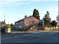
House with disused external staircase, Langwathby
At the junction of Back Lane and Salkeld Road.
Image: © Christine Johnstone
Taken: 31 Jan 2019
0.06 miles
3
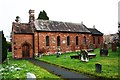
St Peter's Church
There is an OS benchmark Image on the left hand side of the church
Image: © Luke Shaw
Taken: 19 Feb 2020
0.08 miles
4
Langwathby St Peter?s
Viewed on a crisp winter morning with frost still showing on the grass.
Image: © Mary and Angus Hogg
Taken: 18 Dec 2021
0.08 miles
5
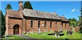
St Peter's Church
St Peter's Church, Langwathby.
Image: © Peter McDermott
Taken: 10 Jul 2022
0.08 miles
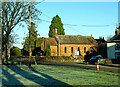
6
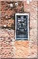
Benchmark bracket on St Peter's Church
Ordnance Survey flush bracket (identifier S8165) benchmark levelled at 98.699m above Newlyn Datum in 1972
Image: © Luke Shaw
Taken: 19 Feb 2020
0.08 miles
7
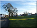
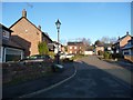
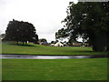
North end of the village green, Langwathby
Looking south.
Image: © Christine Johnstone
Taken: 31 Jan 2019
0.09 miles
8
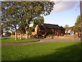
Village Green and church, Langwathby
St Peter's Church was built in 1718, probably a rebuilding of a 13C chantry chapel as the capitals and arches of the north arcade are medieval. The porch and east window are 19C alterations.
Image: © Humphrey Bolton
Taken: 31 Oct 2006
0.12 miles
10
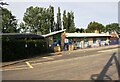
Langwathby CE Primary School, Salkeld Road
Ordnance Survey records indicate that a benchmark was levelled at 98.968m above Newlyn Datum in 1972 on the east face of the building. I suspect the school has been significantly modified since then. See www.bench-marks.org.uk/bm116523
Image: © Roger Templeman
Taken: 14 Sep 2020
0.13 miles