IMAGES TAKEN NEAR TO
Hardys Close, PENRITH, CA10 1JS
Introduction
This page details the photographs taken nearby to Hardys Close, CA10 1JS by members of the Geograph project.
The Geograph project started in 2005 with the aim of publishing, organising and preserving representative images for every square kilometre of Great Britain, Ireland and the Isle of Man.

There are currently over 7.5m images from over14,400 individuals and you can help contribute to the project by visiting https://www.geograph.org.uk
Image Map
Images are licensed for reuse under creativecommons.org/licenses/by-sa/2.0
Notes
- Clicking on the map will re-center to the selected point.
- The higher the marker number, the further away the image location is from the centre of the postcode.
Image Listing (15 Images Found)
Images are licensed for reuse under creativecommons.org/licenses/by-sa/2.0
Image
Details
Distance
1
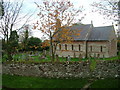
All Saints', Renwick
The village also has a Methodist church, just across the road.
Image: © Andrew Smith
Taken: 7 Feb 2006
0.02 miles
2
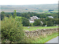
A prospect of Renwick
The North Pennine escarpment rises beyond.
Image: © Oliver Dixon
Taken: 20 Aug 2014
0.03 miles
3
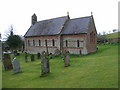
All Saints Church, Renwick
All Saints Church in Renwick was built in 1845 by Rev J Watson to replace an earlier building of 1733.
Image: © Trevor Littlewood
Taken: 29 Aug 2005
0.03 miles
4
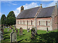
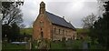
All Saints Church, Renwick, Kirkoswald, Cumbria
A church has stood here for at least 750 years, and probably much longer – the present building, consisting of chancel, nave, and bell-gable with two bells, being perhaps the fourth.
It was designed by the incumbent John Watson, and built at the expense of the local inhabitants in 1845 – when the village was thronged with miners (who were exploiting the coal seams on Renwick Fell), publicans, and tradesmen.
Pevsner dates the double pulpit (for preacher and parish clerk) to 1735. The bell seen in front of the pulpit is mediaeval – perhaps it was rung by James of Lancaster, an excommunicated monk, who in 1362 had "left his cloister and lived wantonly in Renwick". Church registers date from 1649.
Now Renwick, as in 1250, is a home for farmers raising sheep and cattle, and others who value the tranquillity of this unspoilt corner of England. Always beautiful, Renwick has not always been tranquil. The Romans built a road through here to supply their frontier garrisons; and Norsemen settled here too. The wars Edward I waged with Scotland (circa 1300) triggered 300 years of unrest. In 1642/51 Renwick men fell for King Charles at Rowton Heath, Wigan and Worcester. Legend holds that John Tallantire, perhaps about 1610, slew a cockatrice here and won perpetual exemption from tithes.
Image: © Rude Health
Taken: 6 Apr 2013
0.03 miles
6
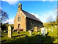
All Saints Church, Renwick
All Saints Church is located in Renwick in the Eden district of Cumbria. There has been a church on this site at Renwick since medieval times. The present church was built 1845-1846, replacing an earlier church of 1737. It is thought to be the fourth church on this site. The church has an unusual two decker pulpit, dating from c.1735.
Image: © Colin Kinnear
Taken: 1 Dec 2021
0.04 miles
7
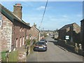
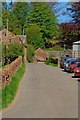
Looking along the main street in Renwick
Image: © John Baker
Taken: 29 Mar 2012
0.11 miles
9
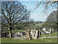
Wall fragment with stile
A curious feature close to the village of Renwick. A fence rises between fields beside which runs the route of a public footpath. The footpath crosses the barrier from one side to the other but at that point, and only there, the fencing is replaced by a short section of walling into which is built the stile.
Image: © Trevor Littlewood
Taken: 29 Mar 2018
0.13 miles
10
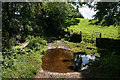
Renwick
Track near Gibson's Well at Renwick.
Image: © Peter McDermott
Taken: 4 Sep 2011
0.14 miles