IMAGES TAKEN NEAR TO
Renwick, PENRITH, CA10 1JQ
Introduction
This page details the photographs taken nearby to CA10 1JQ by members of the Geograph project.
The Geograph project started in 2005 with the aim of publishing, organising and preserving representative images for every square kilometre of Great Britain, Ireland and the Isle of Man.

There are currently over 7.5m images from over14,400 individuals and you can help contribute to the project by visiting https://www.geograph.org.uk
Image Map
Images are licensed for reuse under creativecommons.org/licenses/by-sa/2.0
Notes
- Clicking on the map will re-center to the selected point.
- The higher the marker number, the further away the image location is from the centre of the postcode.
Image Listing (6 Images Found)
Images are licensed for reuse under creativecommons.org/licenses/by-sa/2.0
Image
Details
Distance
1
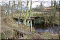
The Bridge over Raven Beck
The walk from Kirkoswald up Raven Beck is one of great pleasure, with the beck babbling away to your right it is one of the nicest walks in the area.
Image: © Keith Wright
Taken: 18 Mar 2006
0.16 miles
2
Low Mill in the valley of the Raven Beck
Narrow back road that passes through Low Mill and Park Head.
Image: © manstein
Taken: 6 Nov 2020
0.16 miles
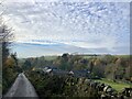
3

Todbank Farm
The North Pennine escarpment on the skyline.
Image: © Oliver Dixon
Taken: 20 Aug 2014
0.16 miles
4
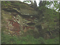
Disused quarry by Raven Beck
A small working of soft red sandstone beside the beck. Most likely dating to Victorian times judging by the graffiti carved on the walls.
Image: © Karl and Ali
Taken: 3 Sep 2017
0.16 miles
5
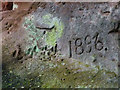
Graffiti in disused quarry by Raven Beck
The carved year '1896' on the wall of Image
Image: © Karl and Ali
Taken: 3 Sep 2017
0.16 miles
6
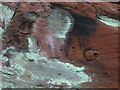
Graffiti in disused quarry by Raven Beck (2)
This could be a pair of initials: 'JL' and 'JO' (or 'JC' or 'JG'?) carved on the face of Image
Image: © Karl and Ali
Taken: 3 Sep 2017
0.16 miles