IMAGES TAKEN NEAR TO
Unthank, Gamblesby, PENRITH, CA10 1JB
Introduction
This page details the photographs taken nearby to CA10 1JB by members of the Geograph project.
The Geograph project started in 2005 with the aim of publishing, organising and preserving representative images for every square kilometre of Great Britain, Ireland and the Isle of Man.

There are currently over 7.5m images from over14,400 individuals and you can help contribute to the project by visiting https://www.geograph.org.uk
Image Map
Images are licensed for reuse under creativecommons.org/licenses/by-sa/2.0
Notes
- Clicking on the map will re-center to the selected point.
- The higher the marker number, the further away the image location is from the centre of the postcode.
Image Listing (9 Images Found)
Images are licensed for reuse under creativecommons.org/licenses/by-sa/2.0
Image
Details
Distance
1
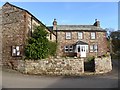
House in Unthank
The noticeboard for this tiny village is on the wall.
Image: © Oliver Dixon
Taken: 11 Nov 2016
0.00 miles
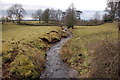
3
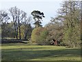
Hazelrigg Beck at Unthank
Looking downstream.
Image: © Oliver Dixon
Taken: 28 Sep 2014
0.09 miles
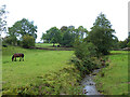
5
Horse beside Hazelrigg Beck
Probably the same horse as in Image
Image: © Oliver Dixon
Taken: 11 Nov 2016
0.10 miles
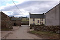
6
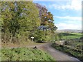
Road junction at Unthank
The road is followed by National Cycle Network route 68 - the Pennine Cycleway.
Image: © Oliver Dixon
Taken: 11 Nov 2016
0.11 miles
7
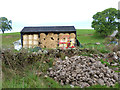
Barn at Unthank
With bales of straw, farm machinery and a pile of stones.
Image: © Oliver Dixon
Taken: 28 Sep 2014
0.16 miles
8
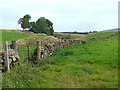
Crofton Sike
Valley and stream at Unthank.
Image: © Oliver Dixon
Taken: 28 Sep 2014
0.19 miles
9
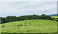
Domed Field with cattle
The field lies south-east of the village of Unthank and south of a tree-lined stream, probably named Limekiln Beck.
Image: © Trevor Littlewood
Taken: 20 Aug 2021
0.25 miles