IMAGES TAKEN NEAR TO
Melmerby, PENRITH, CA10 1HP
Introduction
This page details the photographs taken nearby to CA10 1HP by members of the Geograph project.
The Geograph project started in 2005 with the aim of publishing, organising and preserving representative images for every square kilometre of Great Britain, Ireland and the Isle of Man.

There are currently over 7.5m images from over14,400 individuals and you can help contribute to the project by visiting https://www.geograph.org.uk
Image Map
Images are licensed for reuse under creativecommons.org/licenses/by-sa/2.0
Notes
- Clicking on the map will re-center to the selected point.
- The higher the marker number, the further away the image location is from the centre of the postcode.
Image Listing (8 Images Found)
Images are licensed for reuse under creativecommons.org/licenses/by-sa/2.0
Image
Details
Distance
1
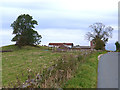
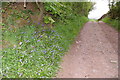
Todhills Farm
On the minor road north of Melmerby which is followed by the Pennine Cycleway (National Cycle Network route 68).
Image: © Oliver Dixon
Taken: 28 Sep 2014
0.01 miles
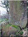
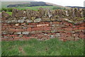
3
Bench mark on wall, Little Todhills
At an altitude of 182.7251m asl.
Image: © Karl and Ali
Taken: 28 Jan 2012
0.15 miles
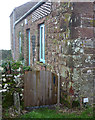
4
Bench mark on broken gatepost, Gamblesby to Melmerby road
At a height of 184.7618m asl.
Image: © Karl and Ali
Taken: 28 Jan 2012
0.16 miles
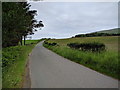
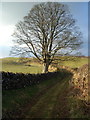
6
Typical local red sandstone wall
Looking towards Melmerby Fell from near Todhills
Image: © Charles Rispin
Taken: 13 May 2006
0.20 miles
8
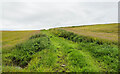
Grassy way separating fields near Gamblesby
The fields both appear to be of stubble so presumably the growth in them not an intended crop. The red tinge is due to extensive amounts of red leg - Persicaria maculosa.
Image: © Trevor Littlewood
Taken: 20 Aug 2021
0.20 miles