IMAGES TAKEN NEAR TO
Croft Place, PENRITH, CA10 1DL
Introduction
This page details the photographs taken nearby to Croft Place, CA10 1DL by members of the Geograph project.
The Geograph project started in 2005 with the aim of publishing, organising and preserving representative images for every square kilometre of Great Britain, Ireland and the Isle of Man.

There are currently over 7.5m images from over14,400 individuals and you can help contribute to the project by visiting https://www.geograph.org.uk
Image Map
Images are licensed for reuse under creativecommons.org/licenses/by-sa/2.0
Notes
- Clicking on the map will re-center to the selected point.
- The higher the marker number, the further away the image location is from the centre of the postcode.
Image Listing (122 Images Found)
Images are licensed for reuse under creativecommons.org/licenses/by-sa/2.0
Image
Details
Distance
2
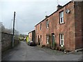
Raven Bank, Kirkoswald
The streets of the village do not seem to have names. Raven Bank is the name of the pair of houses on the right.
Image: © Humphrey Bolton
Taken: 29 Jan 2009
0.04 miles
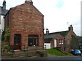
3
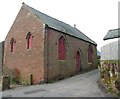
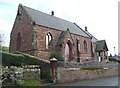
Disused Congregational Chapel, Kirkoswald
Built in 1864, and apparently awaiting a new use.
Image: © Humphrey Bolton
Taken: 29 Jan 2009
0.04 miles
4
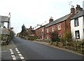
The main street above Market Place, Kirkoswald
The streets of the village do not seem to have names, apart from Market Place, which is also known as The Square.
Image: © Humphrey Bolton
Taken: 29 Jan 2009
0.04 miles
5
Former shop known as West View general stores Kirkoswald
The building on the left has a large ground-floor window, suggesting that it was a shop, but no first-floor windows facing the street. The OS 1:2500 map of 1900 has the caption 'P.O.' nearby, but it could refer to another building.
Image: © Humphrey Bolton
Taken: 29 Jan 2009
0.04 miles
6
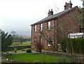
House in the village, Kirkoswald
A pleasant house built with its side to the main street, and with a good view from the garden.
Image: © Humphrey Bolton
Taken: 29 Jan 2009
0.05 miles
7
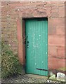
Dated lintel, Kirkoswald
Inscribed 'TA' and 1705, possibly re-used from an older building.
Image: © Humphrey Bolton
Taken: 29 Jan 2009
0.05 miles
8
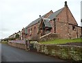
The Methodist Church from the south, Kirkoswald
Built in 1871, with a modern entrance into the chancel.
Image: © Humphrey Bolton
Taken: 29 Jan 2009
0.05 miles
9
The Methodist Church from the north-west, Kirkoswald
Built in 1871, with a modern entrance into the chancel. There are the remains of a belfry on the west gable and an institutional ventilator on the ridge of the roof.
Image: © Humphrey Bolton
Taken: 29 Jan 2009
0.05 miles
10
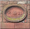
Datestone on the old chapel, Kirkoswald
In 1821 a Wesleyan Chapel was established in what is now two cottages opposite the school. Here is the datestone.
Image: © Humphrey Bolton
Taken: 29 Jan 2009
0.05 miles