IMAGES TAKEN NEAR TO
Lazonby, PENRITH, CA10 1BA
Introduction
This page details the photographs taken nearby to CA10 1BA by members of the Geograph project.
The Geograph project started in 2005 with the aim of publishing, organising and preserving representative images for every square kilometre of Great Britain, Ireland and the Isle of Man.

There are currently over 7.5m images from over14,400 individuals and you can help contribute to the project by visiting https://www.geograph.org.uk
Image Map
Images are licensed for reuse under creativecommons.org/licenses/by-sa/2.0
Notes
- Clicking on the map will re-center to the selected point.
- The higher the marker number, the further away the image location is from the centre of the postcode.
Image Listing (8 Images Found)
Images are licensed for reuse under creativecommons.org/licenses/by-sa/2.0
Image
Details
Distance
1
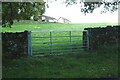
Field gateway near Lazonby Hall Cottages
Ordnance Survey documents indicate that in 1972 a benchmark levelled at 131.679m above Newlyn Datum was verified on a gatepost at this gateway
Image: © Roger Templeman
Taken: 8 Oct 2020
0.07 miles
2
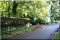
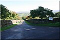
Entrance drive to Lazonby Hall from rural road
There is an Ordnance Survey benchmark Image on a stone at the base of the stone wall near the left hand edge of the image
Image: © Luke Shaw
Taken: 8 Oct 2020
0.10 miles
3
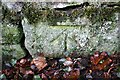
Benchmark on stone at base of wall SE of entrance drive to Lazonby Hall
Ordnance Survey cut mark benchmark verified in 1955 and levelled at 128.089m above Newlyn Datum
Image: © Luke Shaw
Taken: 8 Oct 2020
0.12 miles
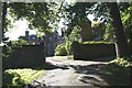
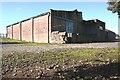
5
Access road to Lazonby Manor Farm Office
Image: © Roger Templeman
Taken: 8 Oct 2020
0.12 miles
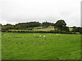
8

Towards Cote Hill Farm
Viewed looking across winter feeding land.
Image: © Mary and Angus Hogg
Taken: 18 Dec 2021
0.19 miles