IMAGES TAKEN NEAR TO
Old Coach Lane, BELFAST, BT9 5PS
Introduction
This page details the photographs taken nearby to Old Coach Lane, BT9 5PS by members of the Geograph project.
The Geograph project started in 2005 with the aim of publishing, organising and preserving representative images for every square kilometre of Great Britain, Ireland and the Isle of Man.

There are currently over 7.5m images from over14,400 individuals and you can help contribute to the project by visiting https://www.geograph.org.uk
Image Map
Images are licensed for reuse under creativecommons.org/licenses/by-sa/2.0
Notes
- Clicking on the map will re-center to the selected point.
- The higher the marker number, the further away the image location is from the centre of the postcode.
Image Listing (11 Images Found)
Images are licensed for reuse under creativecommons.org/licenses/by-sa/2.0
Image
Details
Distance
1
Drop box, Belfast
Drop box at the Upper Malone Road end of the Old Coach Lane.
Image: © Albert Bridge
Taken: 15 Feb 2012
0.05 miles
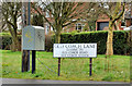
2
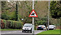
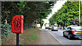
"Beware of horses" sign, Belfast
Officially “accompanied horses or ponies likely to be in or crossing the road” sign on the Upper Malone Road near Olde Gorge Manor. A busy suburban road might seem an unusual place for such a sign but there is an equestrian centre nearby.
Image: © Albert Bridge
Taken: 15 Feb 2012
0.08 miles
3
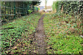
Path, Malone, Belfast
To the best of my knowledge, this path was the previous line of the Old Coach Road before the realignment of its junction with the Upper Malone Road (background).
Image: © Albert Bridge
Taken: 15 Feb 2012
0.08 miles
4
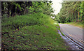
Road, Mary Peters Track, Belfast
The access road, looking out towards the Old Coach Road.
Image: © Albert Bridge
Taken: 6 Jul 2011
0.15 miles
5
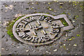
Belfast Water Works cover, Belfast (5)
Fire hydrant, stop-valve and similar covers, installed by the Belfast Water Commissioners, remain common although the body was abolished almost 40 years ago. This example is at Viewfort Park on the Upper Malone Road.
Image: © Albert Bridge
Taken: 15 Feb 2012
0.15 miles
6
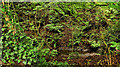
Stream, Mary Peters Track, Belfast
A stream, well below road level, on the south western side of the access road Image
Image: © Albert Bridge
Taken: 6 Jul 2011
0.16 miles
7
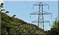
Pylon and power lines near Mary Peters Track, Belfast (1)
One of three pylons carrying the power lines to the south/south west of the Mary Peters Track. Part of the grid from here Image(although the OS map is a bit vague (due to scale) about whether there is junction, between two lines, near Black’s Road, Dunmurry). Image shows the next pylon to the south.
Image: © Albert Bridge
Taken: 6 Jul 2011
0.19 miles
8
The Upper Malone Road, Belfast (2)
Original (left) and present lines of the Upper Malone Road near Finaghy Road South. Malone View Park is at middle right.
Image: © Albert Bridge
Taken: 15 Feb 2012
0.19 miles
9
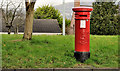
Pillar box, Belfast
EVIIR pillar box (BT9 255) at Malone View Park, Upper Malone Road.
Image: © Albert Bridge
Taken: 15 Feb 2012
0.21 miles
10
Letter box, Finaghy, Belfast
EIIR letter box on Finaghy Road South, near Greystown Park.
Image: © Albert Bridge
Taken: 6 Jul 2011
0.24 miles