IMAGES TAKEN NEAR TO
Crevinish Road, ENNISKILLEN, BT94 1AU
Introduction
This page details the photographs taken nearby to Crevinish Road, BT94 1AU by members of the Geograph project.
The Geograph project started in 2005 with the aim of publishing, organising and preserving representative images for every square kilometre of Great Britain, Ireland and the Isle of Man.

There are currently over 7.5m images from over14,400 individuals and you can help contribute to the project by visiting https://www.geograph.org.uk
Image Map
Images are licensed for reuse under creativecommons.org/licenses/by-sa/2.0
Notes
- Clicking on the map will re-center to the selected point.
- The higher the marker number, the further away the image location is from the centre of the postcode.
Image Listing (43 Images Found)
Images are licensed for reuse under creativecommons.org/licenses/by-sa/2.0
Image
Details
Distance
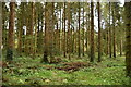
1
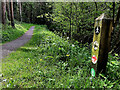
Woodland path, Bunaninver
Heading north-east
Image: © Kenneth Allen
Taken: 22 Apr 2019
0.06 miles
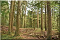
4
Path, Old Castle Archdale
Heading WSW
Image: © Kenneth Allen
Taken: 13 May 2023
0.09 miles
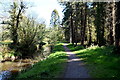
5
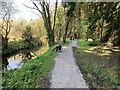
Pathway, Bunaninver
Heading back to Old Castle Archdale car park
Image: © Kenneth Allen
Taken: 25 Apr 2021
0.10 miles
6
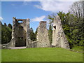
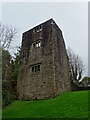
Castle Archdale
The ruined Castle Archdale which was built by the Archdale family who came to the area during the Plantation of Ulster. It was destroyed in 1689
Image: © Derek Henry
Taken: 14 May 2010
0.10 miles
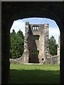
8
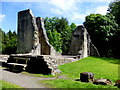
Ruined castle, Old Castle Archdale
ATTACKS, 1641 AND 1689
In the 1641 rising Castle Archdale was captured by Rory Maguire as part of the uprising to retake his lands forfeit in 1607. The heir, William Archdale, was saved by his nurse but the other Archdale children were murdered. The castle was repaired and inhabited until 1689. This time it was burnt out and abandoned.
Image: © Kenneth Allen
Taken: 17 Jul 2014
0.11 miles
9
Castle Archdale
Castle Archdale Country Park is situated about 10 miles north west of Enniskillen. John Archdale from East Anglia came to live here on the shores of Lower Loch Erne in about 1614 after he acquired this estate of 1000 acres as part of the Plantation of Ulster. But the castle he built to defend his property was “put to the torch by Maguire” in the rebellion of 1641 and is now this towered ruin at the southern end of the present Country Park of 230 acres http://www.castlearchdale.com/ 2500 people lived here during the 1939-45 war when the Park was a flying boat base for harrying German submarines in the Western Approaches. They accounted for about ten U-boats and participated in the sinking of the battleship Bismark http://www.geograph.org.uk/photo/789466
Image: © Kenneth Allen
Taken: 7 Sep 2005
0.12 miles