IMAGES TAKEN NEAR TO
Knockbracken Healthcare Park, Saintfield Road, BELFAST, BT8 8SG
Introduction
This page details the photographs taken nearby to Knockbracken Healthcare Park, Saintfield Road, BT8 8SG by members of the Geograph project.
The Geograph project started in 2005 with the aim of publishing, organising and preserving representative images for every square kilometre of Great Britain, Ireland and the Isle of Man.

There are currently over 7.5m images from over14,400 individuals and you can help contribute to the project by visiting https://www.geograph.org.uk
Image Map
Images are licensed for reuse under creativecommons.org/licenses/by-sa/2.0
Notes
- Clicking on the map will re-center to the selected point.
- The higher the marker number, the further away the image location is from the centre of the postcode.
Image Listing (3 Images Found)
Images are licensed for reuse under creativecommons.org/licenses/by-sa/2.0
Image
Details
Distance
1
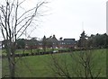
Hospital at the Knockbracken Health Park
Image: © Eric Jones
Taken: 15 Feb 2012
0.15 miles
2
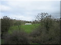
Looking NNE across Purdy's burn.
The stream runs from right to left, and is obscured by the brush. Purdysburn village is named for the stream.
Image: © Brian Shaw
Taken: 22 Mar 2007
0.18 miles
3
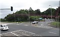
Road leading from the A24 to the Knockbreda Healthcare Park
Image: © Eric Jones
Taken: 30 Jun 2017
0.18 miles