IMAGES TAKEN NEAR TO
Baronsgrange Park, BELFAST, BT8 8LF
Introduction
This page details the photographs taken nearby to Baronsgrange Park, BT8 8LF by members of the Geograph project.
The Geograph project started in 2005 with the aim of publishing, organising and preserving representative images for every square kilometre of Great Britain, Ireland and the Isle of Man.

There are currently over 7.5m images from over14,400 individuals and you can help contribute to the project by visiting https://www.geograph.org.uk
Image Map
Images are licensed for reuse under creativecommons.org/licenses/by-sa/2.0
Notes
- Clicking on the map will re-center to the selected point.
- The higher the marker number, the further away the image location is from the centre of the postcode.
Image Listing (7 Images Found)
Images are licensed for reuse under creativecommons.org/licenses/by-sa/2.0
Image
Details
Distance
1
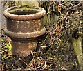
Old boundary post, Carryduff
An old boundary post on the Saintfield side of Carryduff roundabout Image Now worn and rusty, but what seems to be part of the words “Lisburn” and “District” appear at the bottom. I interpret this as a reference to the old (Co Down) Lisburn Rural District Council (RDC) which became Hillsborough Rural District Council Image after partition.
To the best of my knowledge RDC’s did not cross county boundaries. Newry, for example, had two – Newry No1 RDC for Co Down and Newry No2 RDC for Co Armagh. Image shows a Lisburn town boundary post. Hillsborough RDC administered a wide area including Hillsborough, Carryduff, Saintfield and Dromara.
Image: © Albert Bridge
Taken: 12 Dec 2011
0.23 miles
2
Houses at the northern end of the A7 (Saintfield Road)
Image: © Eric Jones
Taken: 27 Apr 2012
0.23 miles
3
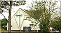
Carryduff (CoI) parish church (1)
At the corner of the Saintfield and Comber Roads, St Ignatius (CoI) parish church was built in 1969. At the time Carryduff was changing from a village to a suburb of Belfast. This is the side on the Comber road. See also Image
Image: © Albert Bridge
Taken: 13 Aug 2009
0.23 miles
4
Eastbank Road, Carryduff
This is a cul-de-sac leading off the A24.
Image: © Eric Jones
Taken: 27 Apr 2012
0.23 miles
5
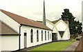
Carryduff (CoI) parish church (2)
See Image The façade on the Saintfield Road – the one seen by anyone travelling between Belfast and Downpatrick.
Image: © Albert Bridge
Taken: 13 Aug 2009
0.24 miles
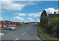
6
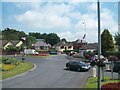
The junction of the A7 and A24 at Carryduff Roundabout
Image: © Eric Jones
Taken: 10 Jul 2015
0.24 miles
7
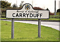
Welcome to Carryduff
Carryduff has the postcode “BT8” putting it within the Belfast postal area but, for local government purposes, it lies within Castlereagh. Castlereagh Borough Council was to have been abolished under the planned reduction in the number of councils – a reform which seems to have become dormant, if not actually dead. This sign is on the Belfast side of Carryduff roundabout Image
Image: © Albert Bridge
Taken: 12 Dec 2011
0.25 miles