IMAGES TAKEN NEAR TO
Drumcairn Close, BELFAST, BT8 8HQ
Introduction
This page details the photographs taken nearby to Drumcairn Close, BT8 8HQ by members of the Geograph project.
The Geograph project started in 2005 with the aim of publishing, organising and preserving representative images for every square kilometre of Great Britain, Ireland and the Isle of Man.

There are currently over 7.5m images from over14,400 individuals and you can help contribute to the project by visiting https://www.geograph.org.uk
Image Map
Images are licensed for reuse under creativecommons.org/licenses/by-sa/2.0
Notes
- Clicking on the map will re-center to the selected point.
- The higher the marker number, the further away the image location is from the centre of the postcode.
Image Listing (41 Images Found)
Images are licensed for reuse under creativecommons.org/licenses/by-sa/2.0
Image
Details
Distance
1
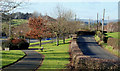
Drumcairn Close, Belfast
A well-landscaped group of bungalows on the southern side of the Milltown Road.
Image: © Albert Bridge
Taken: 3 May 2012
0.01 miles
2
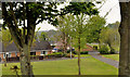
Milltown Hill, Belfast
A suburban road connecting the tranquil and rural Ballylesson Road Image to the noisy Milltown Road Image Previously seen, on a dull day, 3½ years ago Image
Image: © Albert Bridge
Taken: 19 Nov 2011
0.03 miles
3
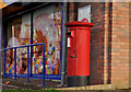
Pillar box, Belfast
Image: © Albert Bridge
Taken: 19 Nov 2011
0.05 miles
4
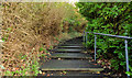
Steps, Belvoir, Belfast
Image: © Albert Bridge
Taken: 19 Nov 2011
0.07 miles
5
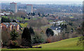
The view from the Minnowburn path, Belfast
The path from the Minnowburn bridge to Terrace Hill has good views over south east Belfast. This view is approximately east from near the top of the hill. The two main features are the Belvoir Park flats Image at top left and the Milltown Road Image just above the white building at middle/right.
Image: © Albert Bridge
Taken: 2 Apr 2010
0.08 miles
6
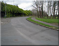
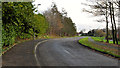
Milltown Hill, Belvoir
A short road connecting the Milltown Road with the Ballylesson Road.
Image: © Rossographer
Taken: 9 Apr 2008
0.08 miles
7
The Old Milltown Road, Belfast
The Old Milltown Road (right), once a country road south east of Belfast and now bypassed by the Milltown Road Image (left). The Belvoir estate is out of picture on the right. Image shows the western end of the road.
Image: © Albert Bridge
Taken: 8 Feb 2010
0.08 miles
8
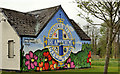
"Dreamscheme" mural, Belfast
A “Dreamscheme” (community scheme) mural near Ballycairn Drive on the Milltown Road.
Image: © Albert Bridge
Taken: 3 May 2012
0.09 miles
9
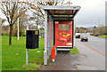
Bus shelter, Belvoir, Belfast
A bus shelter, on the Milltown Road, close to Milltown Hill. It replaced this one Image
Image: © Albert Bridge
Taken: 15 Jan 2014
0.09 miles
10
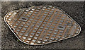
Westfair access cover, Belfast
A “Westfair” access cover, at Milltown Hill Image, just north of the bridge Image I have no information about this foundry. The only reference, on the web, is one other example on Flickr.
Image: © Albert Bridge
Taken: 3 May 2012
0.10 miles