IMAGES TAKEN NEAR TO
Milltown Hill, BELFAST, BT8 8HB
Introduction
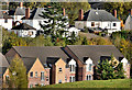
This page details the photographs taken nearby to Milltown Hill, BT8 8HB by members of the Geograph project.
The Geograph project started in 2005 with the aim of publishing, organising and preserving representative images for every square kilometre of Great Britain, Ireland and the Isle of Man.

There are currently over 7.5m images from over14,400 individuals and you can help contribute to the project by visiting https://www.geograph.org.uk
Image Map
Images are licensed for reuse under creativecommons.org/licenses/by-sa/2.0
Notes
- Clicking on the map will re-center to the selected point.
- The higher the marker number, the further away the image location is from the centre of the postcode.
Image Listing (127 Images Found)
Images are licensed for reuse under creativecommons.org/licenses/by-sa/2.0
Image
Details
Distance
1
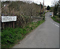
Milltown Hill, Ballynahatty
Further back along the road from Image at Ballynahatty on the Ballylesson Road. This part of the road is a bridge over the Minnowburn River.
Image: © Rossographer
Taken: 9 Apr 2008
0.01 miles
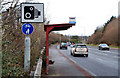
2
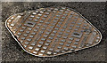
Westfair access cover, Belfast
A “Westfair” access cover, at Milltown Hill Image, just north of the bridge Image I have no information about this foundry. The only reference, on the web, is one other example on Flickr.
Image: © Albert Bridge
Taken: 3 May 2012
0.01 miles
3
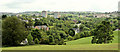
Suburban view from Minnowburn, Belfast (June 2014)
The view towards the Milltown Road and Belvoir from the path to Terrace Hill. The two tall buildings are the Belvoir flats Image Minnowburn Mews Image is below them.
Image: © Albert Bridge
Taken: 5 Jun 2014
0.03 miles
4
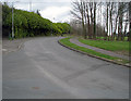
Milltown Hill, Belvoir
A short road connecting the Milltown Road with the Ballylesson Road.
Image: © Rossographer
Taken: 9 Apr 2008
0.03 miles
5
Minnowburn Mews, Belfast
Apartments (foreground) between Milltown Hill Image, the Milltown Road Image and the Sandpit Field Image
Image: © Albert Bridge
Taken: 3 Nov 2012
0.04 miles
6
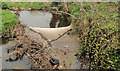
The Purdy's Burn, Belfast
See Image (April 2008). Today’s view, upstream, from the bridge at Milltown Hill, with the river clogged by an old tyre and plenty of natural debris.
Image: © Albert Bridge
Taken: 19 Apr 2012
0.04 miles
7
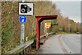
Disused bus shelter, Belfast
See Image (December 2010). The stop is now further east Image along the Milltown Road but the shelter remains.
Image: © Albert Bridge
Taken: 15 Jan 2014
0.04 miles
8
Purdy's Burn at Ballynahatty [1]
Looking downstream towards Minnowburn Beeches, Purdy's Burn river from Milltown Hill near Ballynahatty.
Image: © Rossographer
Taken: 9 Apr 2008
0.05 miles
9
Bus shelter near Shaw's Bridge and Belvoir, Belfast
Non-standard shelter on the Milltown Road Image, near Minnowburn Mews. See also Image (January 2014).
Image: © Albert Bridge
Taken: 13 Dec 2010
0.05 miles
10
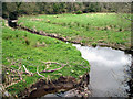
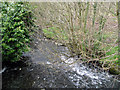
Purdy's Burn at Ballynahatty [2]
Purdy's Burn river near Ballynahatty. This is the view looking upstream from Milltown Hill.
Image: © Rossographer
Taken: 9 Apr 2008
0.06 miles