IMAGES TAKEN NEAR TO
Killynure Crescent, BELFAST, BT8 8EF
Introduction
This page details the photographs taken nearby to Killynure Crescent, BT8 8EF by members of the Geograph project.
The Geograph project started in 2005 with the aim of publishing, organising and preserving representative images for every square kilometre of Great Britain, Ireland and the Isle of Man.

There are currently over 7.5m images from over14,400 individuals and you can help contribute to the project by visiting https://www.geograph.org.uk
Image Map
Images are licensed for reuse under creativecommons.org/licenses/by-sa/2.0
Notes
- Clicking on the map will re-center to the selected point.
- The higher the marker number, the further away the image location is from the centre of the postcode.
Image Listing (26 Images Found)
Images are licensed for reuse under creativecommons.org/licenses/by-sa/2.0
Image
Details
Distance
1
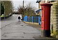
Pillar box, Carryduff
GR pillar box, on the Church Road, opposite the Killynure Road.
Image: © Albert Bridge
Taken: 12 Dec 2011
0.06 miles
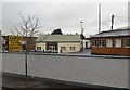
2
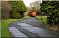
Ashley Park, Carryduff
Located off Church Road - one of the older developments in the area.
Image: © Dean Molyneaux
Taken: 13 Dec 2009
0.07 miles
3
Carryduff (CoI) parish church (2)
See Image The façade on the Saintfield Road – the one seen by anyone travelling between Belfast and Downpatrick.
Image: © Albert Bridge
Taken: 13 Aug 2009
0.08 miles
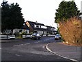
4
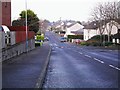
Killynure Road, Carryduff
In the dormitory town of Carryduff - six miles from central Belfast.
Image: © Dean Molyneaux
Taken: 13 Dec 2009
0.09 miles
5
Carryduff (CoI) parish church (1)
At the corner of the Saintfield and Comber Roads, St Ignatius (CoI) parish church was built in 1969. At the time Carryduff was changing from a village to a suburb of Belfast. This is the side on the Comber road. See also Image
Image: © Albert Bridge
Taken: 13 Aug 2009
0.09 miles
6
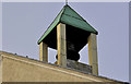
Carryduff Presbyterian church (2)
See Image The belfry.
Image: © Albert Bridge
Taken: 12 Dec 2011
0.13 miles
7
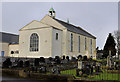
Carryduff Presbyterian church (1)
See Image (November 2005). Church and graveyard on the Church Road. The congregation dates from 1838. The church from 1841. The name of the architect does not seem to have been recorded. The first minister was the Rev. Hugh Brown although the first service was conducted by a better-known member of the clergy Image Image shows the bell and belfry.
Image: © Albert Bridge
Taken: 12 Dec 2011
0.13 miles
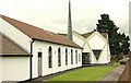
8
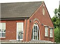
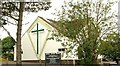
Carryduff gospel hall
On the Comber Road opposite the Church of Ireland Image Architecturally far removed from the traditional idea of a gospel hall Image
Image: © Albert Bridge
Taken: 13 Aug 2009
0.15 miles
9
The old Saintfield Road, Carryduff
Once part of the Saintfield Road, subsequently abandoned and now a lay-by with bollards at the Saintfield end. Replaced by Image where it can be seen at middle top. The sign, at the start of the 40mph speed limit, approaching Carryduff, is to the left of the van.
Image: © Albert Bridge
Taken: 12 Dec 2011
0.15 miles