IMAGES TAKEN NEAR TO
Killynure Road, BELFAST, BT8 8EB
Introduction
This page details the photographs taken nearby to Killynure Road, BT8 8EB by members of the Geograph project.
The Geograph project started in 2005 with the aim of publishing, organising and preserving representative images for every square kilometre of Great Britain, Ireland and the Isle of Man.

There are currently over 7.5m images from over14,400 individuals and you can help contribute to the project by visiting https://www.geograph.org.uk
Image Map
Images are licensed for reuse under creativecommons.org/licenses/by-sa/2.0
Notes
- Clicking on the map will re-center to the selected point.
- The higher the marker number, the further away the image location is from the centre of the postcode.
Image Listing (6 Images Found)
Images are licensed for reuse under creativecommons.org/licenses/by-sa/2.0
Image
Details
Distance
1
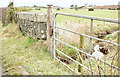
Bridge and gate, Killinure, Carryduff (February 2015)
A bridge carrying the Killynure Road across a stream. The gate leads to a field on the eastern side of the road.
Image: © Albert Bridge
Taken: 18 Feb 2015
0.15 miles
2
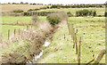
Stream, Killinure, Carryduff (February 2015)
A stream, on the eastern side of the Killynure Road, seen from this bridge Image
Image: © Albert Bridge
Taken: 18 Feb 2015
0.15 miles
3
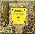
Cathodic protection marker post, Killinure near Carryduff (February 2015)
A post marking a cathodic protection http://en.wikipedia.org/wiki/Cathodic_protection test point on the western side of the Killynure Road. The Aquarius pipeline was “Aquarius 3 was a Design and Build contract for a £23m water treatment works in County Down, Northern Ireland. The 155MLD plant was designed to supply 50% of the water to Greater Belfast and County Down and meet the very latest EU standards. This was one of the largest WTW to be built in Northern Ireland in the last 30 years and incorporated the latest technology to deal with cryptosporidium.” See http://www.farrans.com/fs/doc/projects/Farrans_Water_&_Wastewater_Brochure.pdf.
Image: © Albert Bridge
Taken: 18 Feb 2015
0.16 miles
4
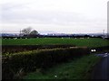
Killinure Townland
A view towards Belfast with the distinct shape of Divis mountain visible in the distance.
Taken from the Killynure Road, south of Carryduff - at the junction with Killynure Road West.
Townland of Killinure.
Image: © Dean Molyneaux
Taken: 13 Dec 2009
0.18 miles
5
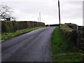
Killynure Road, Carryduff
For those with an interest in 'how things used to be' - this is the old coach road from Belfast to Downpatrick - the 1830s OS map on www.osi.ie shows it well.
Townland of Ouley.
Image: © Dean Molyneaux
Taken: 13 Dec 2009
0.18 miles
6
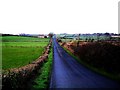
Killynure Road, Carryduff
For those with an interest in 'how things used to be' - this is the old coach road from Belfast to Downpatrick - the 1830s OS map on www.osi.ie shows it well.
Looking towards Carryduff. Townland of Killinure.
Image: © Dean Molyneaux
Taken: 13 Dec 2009
0.19 miles