IMAGES TAKEN NEAR TO
Purdy's Lane, BELFAST, BT8 7AR
Introduction
This page details the photographs taken nearby to Purdy's Lane, BT8 7AR by members of the Geograph project.
The Geograph project started in 2005 with the aim of publishing, organising and preserving representative images for every square kilometre of Great Britain, Ireland and the Isle of Man.

There are currently over 7.5m images from over14,400 individuals and you can help contribute to the project by visiting https://www.geograph.org.uk
Image Map
Images are licensed for reuse under creativecommons.org/licenses/by-sa/2.0
Notes
- Clicking on the map will re-center to the selected point.
- The higher the marker number, the further away the image location is from the centre of the postcode.
Image Listing (61 Images Found)
Images are licensed for reuse under creativecommons.org/licenses/by-sa/2.0
Image
Details
Distance
1
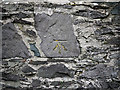
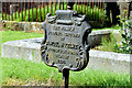
Bench Mark, Belfast
Cut bench mark on a wall on Church Road in south Belfast.
The mark is 46.04 metres above MSL.
See also http://www.geograph.org.uk/search.php?i=11037856 for many other examples I have found.
Image: © Rossographer
Taken: 19 Mar 2010
0.03 miles
2
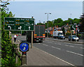
Newtownbreda Road, Belfast
Part of the Newtownbreda Road (the A55 'Outer Ring') in Belfast.
Image: © Rossographer
Taken: 12 May 2008
0.04 miles
3
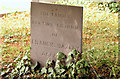
Hazley headstone, Knockbreda churchyard, Belfast
A simple slate grave marker with the inscription “THE FAMILY BURYING GROUND OF FRANCES HAZLEY BELFAST” (no dates).
Image: © Albert Bridge
Taken: 6 Aug 2014
0.06 miles
4
![Church Road, Newtownbreda [2]](https://s2.geograph.org.uk/photos/79/95/799554_1c51916c_120x120.jpg)
Church Road, Newtownbreda [2]
Looking down Church Road in the direction of central Belfast.
Image: © Rossographer
Taken: 12 May 2008
0.06 miles
5
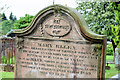
"Brown" headstone, Knockbreda churchyard, Belfast
A headstone with the inscription “IN MEMORY OF MARY ELLEN THE BELOVED WIFE OF GEORGE BROWN MARINER OF ANNAN, WHO DIED AT BELFAST 19TH MAY 1856. AGED 52 YEARS. ALSO OF MARY, WIDOW OF JOHN BROWN MARINER & MOTHER OF THE ABOVE NAMED GEORGE BROWN WHO DIED AT BELFAST 26TH MARCH 1859, AGED 69 YEARS.”
Image: © Albert Bridge
Taken: 6 Aug 2014
0.06 miles
6
McKelvey burying ground, Knockbreda churchyard, Belfast
A cast-iron grave marker, similar to this one made by the Millfield Foundry Image, with the following inscription “THE FAMILY BURYING GROUND OF SAMUEL McKELVEY WOODSTOCK ROAD BELFAST 1894”.
Image: © Albert Bridge
Taken: 6 Aug 2014
0.06 miles
7
![Knockbreda Parish Church, Belfast [detail]](https://s2.geograph.org.uk/photos/79/97/799730_7886ee05_120x120.jpg)
Knockbreda Parish Church, Belfast [detail]
Detail of the spire on Image
Image: © Rossographer
Taken: 12 May 2008
0.07 miles
8
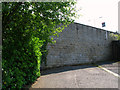
Church Road, Newtownbreda
Church Road in Newtownbreda, Belfast, ends abruptly at this large wall. I imagine that it once travelled on towards the Saintfield Road until the 'Outer Ring' Image was constructed.
Image: © Rossographer
Taken: 12 May 2008
0.07 miles
9
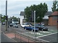
Stationary traffic on the A55 at the cross roads with the A24
Image: © Eric Jones
Taken: 30 Jun 2015
0.07 miles
10
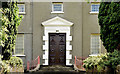
Knockbreda (Church of Ireland) parish church, Belfast (August 2014)
See Image in May 2008. The trees have grown sufficiently, over the last six years, so that an identical photograph is no longer possible. This is part of the front of the church, which, in this view, has the appearance of a rather grand Georgian house. This link http://www.knockbredaparish.org/about/history/ is to the official history. It’s worth recording that Knockbreda, now pure suburbia, was a rural area when the church was built.
Image: © Albert Bridge
Taken: 6 Aug 2014
0.08 miles