IMAGES TAKEN NEAR TO
Windermere Park, BELFAST, BT8 6QZ
Introduction
This page details the photographs taken nearby to Windermere Park, BT8 6QZ by members of the Geograph project.
The Geograph project started in 2005 with the aim of publishing, organising and preserving representative images for every square kilometre of Great Britain, Ireland and the Isle of Man.

There are currently over 7.5m images from over14,400 individuals and you can help contribute to the project by visiting https://www.geograph.org.uk
Image Map
Images are licensed for reuse under creativecommons.org/licenses/by-sa/2.0
Notes
- Clicking on the map will re-center to the selected point.
- The higher the marker number, the further away the image location is from the centre of the postcode.
Image Listing (17 Images Found)
Images are licensed for reuse under creativecommons.org/licenses/by-sa/2.0
Image
Details
Distance
1
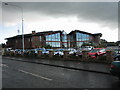
Four Winds Bar/Grill and Restaurant
Rebuilt several times due to various explosions during the Troubles, this large hostelry is well patronised.
Image: © Brian Shaw
Taken: 28 Nov 2005
0.08 miles
2

Ballymaconaghy Road, Four Winds, Belfast
One of the four 'wynds'. This road leads to Knockbracken and Mount Ober Golf Club.
Development along here didn't start in earnest until the late 1990s.
Image: © Dean Molyneaux
Taken: 24 Sep 2009
0.13 miles
3
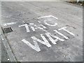
"7A/C Wait!" - Four Winds Terminus, Belfast
An interesting road marking at the Four Winds terminus (now just a bus stop - the terminus has moved up to Laurelgrove).
The 7A/C are the Translink Metro services that run from here to the city centre via Forestside and the Ormeau Road.
Image: © Dean Molyneaux
Taken: 24 Sep 2009
0.14 miles
4
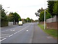
Cairnshill Road, Four Winds, Belfast
This road was realigned and widened in 1986 to cope with the demands of this fast-growing suburb. Looking towards the Four Winds roundabout.
Image: © Dean Molyneaux
Taken: 24 Sep 2009
0.15 miles
5

Four Winds Roundabout, Belfast
The name 'Four Winds' (which is now applied to the whole area) derives, I think, from the crossroads here being called the Four 'Wynds' (Scots for 'roads').
These rural roads have long since been widened.
The road emerging from the left is Newton Park, straight ahead is Manse Road, to the right is the Ballymaconaghy Road - and behind me is the Cairnshill Road.
Image: © Dean Molyneaux
Taken: 24 Sep 2009
0.15 miles
6
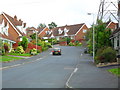
Upper Malvern Park, Four Winds, Belfast
The main artery in the Malvern development, built in 1986 by Fraser Homes Ltd. Off the Cairnhill Road at the Four Winds.
Image: © Dean Molyneaux
Taken: 24 Sep 2009
0.15 miles
7
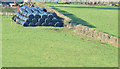
Silage bales, Belfast (February 2015)
Silage bales in a field close to the Ballymaconaghy Road – an area marking the boundary between suburban housing and agriculture
Image: © Albert Bridge
Taken: 6 Feb 2015
0.15 miles
8

Four Winds Bar & Restaurant (2009)
Slightly facelifted since 2005, see:Image
Now officially known as "Ink" - most people still call it 'the Winds'.
On Newton Park, Belfast 8.
Image: © Dean Molyneaux
Taken: 24 Sep 2009
0.16 miles
9
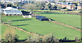
Suburbs and farm, Belfast (February 2015)
The view towards the Manse Road, from close to here Image, showing the boundary/current limit of development between town and country.
Image: © Albert Bridge
Taken: 6 Feb 2015
0.16 miles
10
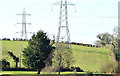
Pylons and power lines, Belfast (February 2015)
Pylons and power lines on the south western side of the path. This one Image is nearest the camera.
Image: © Albert Bridge
Taken: 6 Feb 2015
0.17 miles