IMAGES TAKEN NEAR TO
Glendale Park, BELFAST, BT8 6HT
Introduction
This page details the photographs taken nearby to Glendale Park, BT8 6HT by members of the Geograph project.
The Geograph project started in 2005 with the aim of publishing, organising and preserving representative images for every square kilometre of Great Britain, Ireland and the Isle of Man.

There are currently over 7.5m images from over14,400 individuals and you can help contribute to the project by visiting https://www.geograph.org.uk
Image Map
Images are licensed for reuse under creativecommons.org/licenses/by-sa/2.0
Notes
- Clicking on the map will re-center to the selected point.
- The higher the marker number, the further away the image location is from the centre of the postcode.
Image Listing (30 Images Found)
Images are licensed for reuse under creativecommons.org/licenses/by-sa/2.0
Image
Details
Distance

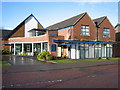
3
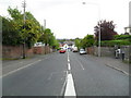
Saintfield Road at Newton Park, Belfast
Looking towards Commons Brae (Image).
Image: © Dean Molyneaux
Taken: 24 Sep 2009
0.09 miles
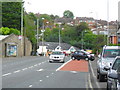
4
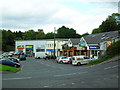
Shops at Commons Brae, Belfast
A busy row of shops along the Saintfield Road at Commons Brae.
Image: © Dean Molyneaux
Taken: 24 Sep 2009
0.09 miles
5
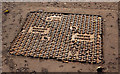
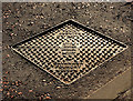
Cavanagh "Python" access cover, Belfast
Continuing the series of named Cavanagh access covers http://www.geograph.org.uk/search.php?i=28245089 this example of a “Python” is on the Saintfield Road, on the outward side of the School Road.
Image: © Albert Bridge
Taken: 23 Jan 2012
0.10 miles
6
Cavanagh "Brunel" access cover, Belfast
A Cavanagh “Brunel” access cover on the Saintfield Road. It clearly shows the foundry’s address as Birr, Co Offaly http://www.geograph.org.uk/browse.php?p=318384 .
Image: © Albert Bridge
Taken: 23 Jan 2012
0.11 miles
7
Newton Park, Four Winds, Belfast
The steepest section of Newton Park - climbing up from the Saintfield road at Inns Cross.
Image: © Dean Molyneaux
Taken: 24 Sep 2009
0.11 miles
8
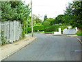
Commons Brae, Belfast
Once a steep cul-de-sac off the Saintfield Road, it now links onto Burnside Avenue.
Image: © Dean Molyneaux
Taken: 24 Sep 2009
0.12 miles
9
Pillar box, Belfast
EIIR pillar box, on the Saintfield Road, near the corner of the School Road.
Image: © Albert Bridge
Taken: 21 Sep 2011
0.13 miles
10
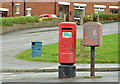
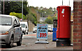
Pillar box and drop box, Belfast
Drop box and EIIR pillar box (BT8 799) outside the shops at Newton Park. Glenholm Park is in the background.
Image: © Albert Bridge
Taken: 28 Dec 2012
0.13 miles