IMAGES TAKEN NEAR TO
Kew Gardens, BELFAST, BT8 6GN
Introduction
This page details the photographs taken nearby to Kew Gardens, BT8 6GN by members of the Geograph project.
The Geograph project started in 2005 with the aim of publishing, organising and preserving representative images for every square kilometre of Great Britain, Ireland and the Isle of Man.

There are currently over 7.5m images from over14,400 individuals and you can help contribute to the project by visiting https://www.geograph.org.uk
Image Map
Images are licensed for reuse under creativecommons.org/licenses/by-sa/2.0
Notes
- Clicking on the map will re-center to the selected point.
- The higher the marker number, the further away the image location is from the centre of the postcode.
Image Listing (25 Images Found)
Images are licensed for reuse under creativecommons.org/licenses/by-sa/2.0
Image
Details
Distance
1
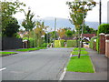
Pennington Park, Four Winds, Belfast
A mature street off the Cairnshill Road in the Four Winds suburb of Belfast.
Image: © Dean Molyneaux
Taken: 24 Sep 2009
0.11 miles
2
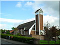
Saintfield Road Presbyterian Church, Belfast
At Myrtledene Road. Opened in 1962 in light of the rapid expansion of Belfast towards Carryduff.
Image: © Dean Molyneaux
Taken: 24 Sep 2009
0.12 miles
3
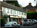
Shops on the Saintfield Road at Beechill, Belfast
It seems that you can't have a row of shops in Belfast without an off-sales of some description - evident here along the Saintfield Road at Beechill.
Image: © Dean Molyneaux
Taken: 24 Sep 2009
0.13 miles
4

The old Saintfield Road at Myrtledene, Belfast
The old road to everywhere in South Down, thankfully now replaced.
Image: © Dean Molyneaux
Taken: 24 Sep 2009
0.14 miles
5
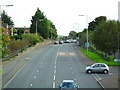
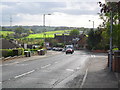
Saintfield Road looking south, Belfast
Looking along the A24 towards Carryduff and Newcastle at Beechill.
Image: © Dean Molyneaux
Taken: 24 Sep 2009
0.15 miles
6
Cairnshill Road, Four Winds, Belfast
Looking down towards the Saintfield Road and Purdysburn.
Image: © Dean Molyneaux
Taken: 24 Sep 2009
0.15 miles
7
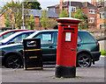
Pillar box, Belfast
Leaning EIIR pillar box, at Beechill Avenue on the Saintfield Road, near Hill Green.
Image: © Albert Bridge
Taken: 21 Sep 2011
0.16 miles
8
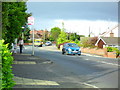
Cairnshill Road, Four Winds, Belfast
Climbing up from the Saintfield Road into the Four Winds area. The Four Winds began on a greenfield site in the early 1960s - development continues even today albeit at a much slower rate.
Image: © Dean Molyneaux
Taken: 24 Sep 2009
0.16 miles
9

The Saintfield Road, Belfast (2)
The view, outward – towards Carryduff, from this footbridge Image
Image: © Albert Bridge
Taken: 21 Sep 2011
0.17 miles
10
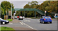
Footbridge, Belfast
A footbridge, across a steep part of the Saintfield Road, at Glenhugh Park (left).
Image: © Albert Bridge
Taken: 21 Sep 2011
0.18 miles