IMAGES TAKEN NEAR TO
Croft Hill Cottages, BELFAST, BT8 6BA
Introduction
This page details the photographs taken nearby to Croft Hill Cottages, BT8 6BA by members of the Geograph project.
The Geograph project started in 2005 with the aim of publishing, organising and preserving representative images for every square kilometre of Great Britain, Ireland and the Isle of Man.

There are currently over 7.5m images from over14,400 individuals and you can help contribute to the project by visiting https://www.geograph.org.uk
Image Map
Images are licensed for reuse under creativecommons.org/licenses/by-sa/2.0
Notes
- Clicking on the map will re-center to the selected point.
- The higher the marker number, the further away the image location is from the centre of the postcode.
Image Listing (14 Images Found)
Images are licensed for reuse under creativecommons.org/licenses/by-sa/2.0
Image
Details
Distance
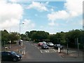
1
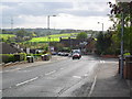
Cairnshill Road, Four Winds, Belfast
Looking down towards the Saintfield Road and Purdysburn.
Image: © Dean Molyneaux
Taken: 24 Sep 2009
0.19 miles
2
Cairnshill Road, Four Winds, Belfast
Climbing up from the Saintfield Road into the Four Winds area. The Four Winds began on a greenfield site in the early 1960s - development continues even today albeit at a much slower rate.
Image: © Dean Molyneaux
Taken: 24 Sep 2009
0.19 miles
3
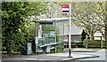
Bus stop and shelter, Cairnshill, Belfast (April 2017)
The Cairnshill Court stop at the Saintfield Road end of the Cairnshill Road. Served by inward Metro 7A and 7C (Laurelgrove and Four Winds to Howard Street).
Image: © Albert Bridge
Taken: 20 Apr 2017
0.21 miles
5
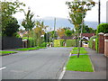
Pennington Park, Four Winds, Belfast
A mature street off the Cairnshill Road in the Four Winds suburb of Belfast.
Image: © Dean Molyneaux
Taken: 24 Sep 2009
0.22 miles
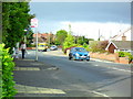
6
Saintfield Road at Cairnshill, Belfast
I'd say this is where Belfast ends these days. After this are a few fields and then you're into Carryduff, which is a major commuter village.
The sticker with 'Golf' is covering the word 'Ski' - Mount Ober dry slopes closed some years back.
Image: © Dean Molyneaux
Taken: 24 Sep 2009
0.22 miles
7
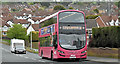
Bus, Cairnshill Road, Belfast (April 2017)
A Metro Wright-bodied Volvo (2384 SFZ 9384) running along the Cairnshill Road with a 7A Four Winds – Howard Street service.
Image: © Albert Bridge
Taken: 20 Apr 2017
0.23 miles
8
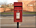
Letter box, Belfast
Post-mounted EIIR letter box (BT8 9999) at the Saintfield Road end of Primrose Hill.
Image: © Albert Bridge
Taken: 23 Jan 2012
0.23 miles
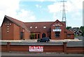
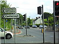
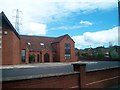
9
Cairnshill Road at its junction with the A24
Image: © Eric Jones
Taken: 10 Jul 2015
0.23 miles
10
Cairnshill Methodist Church, Cairnshill, Belfast
Image: © Eric Jones
Taken: 27 Apr 2012
0.24 miles