IMAGES TAKEN NEAR TO
Lurganboy Road, CASTLEDERG, BT81 7HT
Introduction
This page details the photographs taken nearby to Lurganboy Road, BT81 7HT by members of the Geograph project.
The Geograph project started in 2005 with the aim of publishing, organising and preserving representative images for every square kilometre of Great Britain, Ireland and the Isle of Man.

There are currently over 7.5m images from over14,400 individuals and you can help contribute to the project by visiting https://www.geograph.org.uk
Image Map
Images are licensed for reuse under creativecommons.org/licenses/by-sa/2.0
Notes
- Clicking on the map will re-center to the selected point.
- The higher the marker number, the further away the image location is from the centre of the postcode.
Image Listing (51 Images Found)
Images are licensed for reuse under creativecommons.org/licenses/by-sa/2.0
Image
Details
Distance
1
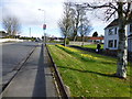
Lurganboy Road, Castlederg
Heading NNE
Image: © Kenneth Allen
Taken: 5 Apr 2016
0.10 miles
2
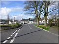
Side road, Castlederg
Heading west to Lurganboy Road
Image: © Kenneth Allen
Taken: 5 Apr 2016
0.11 miles
3
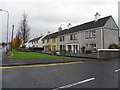
Breezemount Park, Castlederg
It is located along Lurganboy Road
Image: © Kenneth Allen
Taken: 2 Nov 2010
0.12 miles
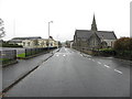
4
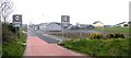
Approaching Castlederg
Heading south towards the town.
Image: © Kenneth Allen
Taken: 27 Mar 2007
0.14 miles
5
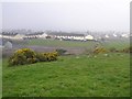
Ground overlooking Castlederg
I was looking for a chambered grave marked on the map but there were so many stones in the field that I gave up.
Image: © Kenneth Allen
Taken: 27 Mar 2007
0.14 miles
6
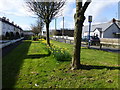
Daffodil display along Breezemount Park
Looking SSW
Image: © Kenneth Allen
Taken: 5 Apr 2016
0.17 miles
7
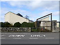
Vacant church property, Castlederg
This was the "new church" which was erected to replace the Gothic style older one. It was built c 1979 at a cost of £ 135,000.00 but the plan proved to include design defects and the worshippers went back to the older church Image]
It was used for a time as a youth club but to bring the structure up to order, it has been estimated that it would take a sum in excess of £1m to cover the cost of renovations, so this building may be designated for demolition.
Anyway to me the older church looks better
Image: © Kenneth Allen
Taken: 5 Apr 2016
0.17 miles
8
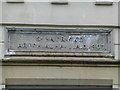
Plaque, St Patrick's Parochial Hall A.D. 1907
Pictured here Image]
Image: © Kenneth Allen
Taken: 5 Apr 2016
0.17 miles
9
Castlefin Road, Castelderg
Heading south
Ahead to the right is Image]
Image: © Kenneth Allen
Taken: 11 Nov 2014
0.18 miles
10
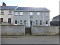
St Patrick's Close, Castlederg
A collection of flats located along Castlefin Road
Image: © Kenneth Allen
Taken: 5 Apr 2016
0.18 miles