IMAGES TAKEN NEAR TO
Rylagh Road, OMAGH, BT79 7SY
Introduction
This page details the photographs taken nearby to Rylagh Road, BT79 7SY by members of the Geograph project.
The Geograph project started in 2005 with the aim of publishing, organising and preserving representative images for every square kilometre of Great Britain, Ireland and the Isle of Man.

There are currently over 7.5m images from over14,400 individuals and you can help contribute to the project by visiting https://www.geograph.org.uk
Image Map
Images are licensed for reuse under creativecommons.org/licenses/by-sa/2.0
Notes
- Clicking on the map will re-center to the selected point.
- The higher the marker number, the further away the image location is from the centre of the postcode.
Image Listing (69 Images Found)
Images are licensed for reuse under creativecommons.org/licenses/by-sa/2.0
Image
Details
Distance
2
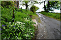
Bluebells and wild garlic along Rylagh Road
See close-up here Image]
Image: © Kenneth Allen
Taken: 10 May 2022
0.06 miles
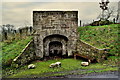
3
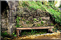
Lime kiln (side wall)
The stone wall was populated with hart-s-tongue plants
Image: © Kenneth Allen
Taken: 24 Oct 2022
0.06 miles
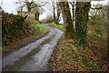
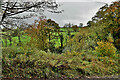
4
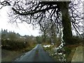
Rylagh Road
Heading SSW at Erganagh Glebe
Image: © Kenneth Allen
Taken: 22 Mar 2013
0.06 miles
5
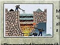
Lime processing (close up of information board)
Men employed in large scale kilns were known as limeburners. They had the unenviable task of putting alternating layers of limestone and turf (peat) into the kiln; a process known as 'eekin'.
Pictured here Image]
Image: © Kenneth Allen
Taken: 24 Oct 2022
0.07 miles
6
Rylagh Townland
Pictured along Rylagh Road
Image: © Kenneth Allen
Taken: 24 Oct 2022
0.07 miles
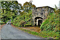
7
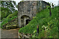
Restored lime kiln, Rylagh
Pictured along Rylagh Road
Image: © Kenneth Allen
Taken: 10 May 2022
0.07 miles
8
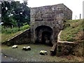
Rylagh Limekiln, Rylagh
Pictured along Rylagh Road, it was re-furbished during the summer
Note the date - 1801
There is a direction sign leading from Glenpark Road Image]
Image: © Kenneth Allen
Taken: 6 Sep 2016
0.08 miles
9
Lime kiln, Rylagh
Pictured along Rylagh Road
There is an information board nearby Image]
Image: © Kenneth Allen
Taken: 14 Jan 2019
0.08 miles
10
Lime kiln, Rylagh
Workers endured harsh conditions. Limekilns were known to present dangers to both workers and visitors. They were considered an excellent source of heat and it is told that people who left the local workhouse, having nowhere to stay at night, had chosen to sleep at Rylagh limekiln by night. Some were found dead in the morning as a result of inhaling deadly fumes from the kiln. Stories of the kiln handed down by our older people, serve as reminders of the relevance this place had in our community at one time.
Pictured along Rylagh Road
Image: © Kenneth Allen
Taken: 24 Oct 2022
0.08 miles