IMAGES TAKEN NEAR TO
Maryville Terrace, OMAGH, BT79 7BZ
Introduction
This page details the photographs taken nearby to Maryville Terrace, BT79 7BZ by members of the Geograph project.
The Geograph project started in 2005 with the aim of publishing, organising and preserving representative images for every square kilometre of Great Britain, Ireland and the Isle of Man.

There are currently over 7.5m images from over14,400 individuals and you can help contribute to the project by visiting https://www.geograph.org.uk
Image Map
Images are licensed for reuse under creativecommons.org/licenses/by-sa/2.0
Notes
- Clicking on the map will re-center to the selected point.
- The higher the marker number, the further away the image location is from the centre of the postcode.
Image Listing (686 Images Found)
Images are licensed for reuse under creativecommons.org/licenses/by-sa/2.0
Image
Details
Distance
1
Footpath, Lisanelly, Omagh
Heading south along the Mountjoy Road
Image: © Kenneth Allen
Taken: 6 Oct 2015
0.01 miles
2
"The Gusset", Omagh
The locals refer to the "V" shaped wedge of land formed at the intersection of the Gortin Road, Mountjoy Road and the Killybrack Road as "The Gusset", something which I only found out recently. The Lisnamallard Burn passes across the road in a culvert at this spot, coming alongside the Circular Road, and then running down the hidden glen between the Grange and the MOD property, to join the river Strule north of the town
Image: © Kenneth Allen
Taken: 13 Oct 2007
0.02 miles
3
Gardenville Avenue, Omagh
In the centre of the site 14 semi-detached cottages called Garden Cottages were demolished to make way for the newer houses.
Image: © Kenneth Allen
Taken: 15 Nov 2007
0.02 miles
4
Bus shelter with advertising panel, Omagh
Pictured along Gortin Road
Image: © Kenneth Allen
Taken: 16 Feb 2023
0.02 miles
5
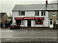
McLernon, Estate Agents & Valuers, Gortin Road, Omagh
The business has relocated from here Image]
Image: © Kenneth Allen
Taken: 16 Feb 2023
0.02 miles
6
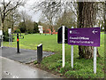
Council Offices sign, Omagh
Pictured at The Grange
Image: © Kenneth Allen
Taken: 29 Mar 2021
0.03 miles
7
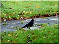
Crow, Omagh
Pictured along Gortin Road, it didn't hang about for too long
Image: © Kenneth Allen
Taken: 18 Nov 2013
0.03 miles
8

Fitness Equipment (1)
Pictured at The Grange
Image: © Kenneth Allen
Taken: 10 Sep 2012
0.03 miles
9
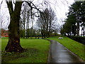
Pathway at The Grange Park, Omagh
The wet morning and my trainers made it slippery underfoot.
Image: © Kenneth Allen
Taken: 1 Apr 2016
0.03 miles
10
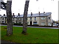
Woodside Terrace, Omagh
Pictured along Mountjoy Road
Image: © Kenneth Allen
Taken: 23 Nov 2015
0.03 miles