IMAGES TAKEN NEAR TO
Dergmoney Avenue, OMAGH, BT78 1HH
Introduction
This page details the photographs taken nearby to Dergmoney Avenue, BT78 1HH by members of the Geograph project.
The Geograph project started in 2005 with the aim of publishing, organising and preserving representative images for every square kilometre of Great Britain, Ireland and the Isle of Man.

There are currently over 7.5m images from over14,400 individuals and you can help contribute to the project by visiting https://www.geograph.org.uk
Image Map
Images are licensed for reuse under creativecommons.org/licenses/by-sa/2.0
Notes
- Clicking on the map will re-center to the selected point.
- The higher the marker number, the further away the image location is from the centre of the postcode.
Image Listing (1104 Images Found)
Images are licensed for reuse under creativecommons.org/licenses/by-sa/2.0
Image
Details
Distance
1
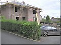
Dergmoney, Omagh
Located off the Dublin Road, they've found a place to squeeze in an extra house.
Image: © Kenneth Allen
Taken: 4 Oct 2006
0.03 miles
2
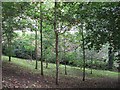
Rear garden, Dergmoney Place, Omagh
A lovely spot but unfortunately there is a down side. The disused railway track used to run behind this area, but now the new through-pass has been constructed in its place and even though the traffic is supposed to slow to 30mph at this spot, it is very noisey even with the planting of the tree barrier.
Image: © Kenneth Allen
Taken: 1 Oct 2007
0.03 miles
3
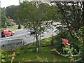
Omagh through-pass
As seen from one of the rear gardens at Dergmoney Place.
Image: © Kenneth Allen
Taken: 1 Oct 2007
0.03 miles
4
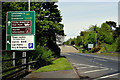
Direction sign, Omagh
Pictured along the Great Northern Road bypass
Image: © Kenneth Allen
Taken: 9 May 2020
0.03 miles
5
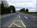
Great Northern Road, Omagh
Heading north-west, this section of the bypass has a 30mph speed limit, and the police often wait on a layby under the bridge to catch speeding motorists.
Image: © Kenneth Allen
Taken: 17 May 2014
0.03 miles
6
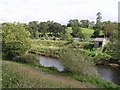
River Drumragh, Omagh
Looking east, the land on the hill is at Creevenagh
Image: © Kenneth Allen
Taken: 23 Sep 2006
0.04 miles
7
Irishtown, Omagh
Looking south towards the new by-pass
Image: © Kenneth Allen
Taken: 10 Sep 2007
0.04 miles
8

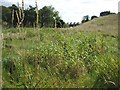
Vacant land, Omagh
It is located between the Dublin Road and the through-pass.
Image: © Kenneth Allen
Taken: 22 Sep 2007
0.04 miles
9
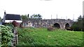
"Campsie Bridge", Irishtown Road, Omagh
Yes! - Campsie Bridge spanning the river Drumragh, along with its toll house, but it was only so known until the erection of the present Campsie Bridge at Lower Market Street in 1838. Now it is called King James Bridge.
Image: © Kenneth Allen
Taken: 11 Nov 2007
0.04 miles
10
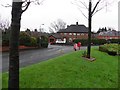
Dergmoney Place, Omagh
Pictured along Dublin Road
Image: © Kenneth Allen
Taken: 31 Dec 2011
0.04 miles