IMAGES TAKEN NEAR TO
Annadale Terrace, BELFAST, BT7 3DH
Introduction
This page details the photographs taken nearby to Annadale Terrace, BT7 3DH by members of the Geograph project.
The Geograph project started in 2005 with the aim of publishing, organising and preserving representative images for every square kilometre of Great Britain, Ireland and the Isle of Man.

There are currently over 7.5m images from over14,400 individuals and you can help contribute to the project by visiting https://www.geograph.org.uk
Image Map
Images are licensed for reuse under creativecommons.org/licenses/by-sa/2.0
Notes
- Clicking on the map will re-center to the selected point.
- The higher the marker number, the further away the image location is from the centre of the postcode.
Image Listing (351 Images Found)
Images are licensed for reuse under creativecommons.org/licenses/by-sa/2.0
Image
Details
Distance
1
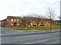
Annadale Terrace, Belfast
A row of red-brick terraced house - constructed in the 1950s along Annadale Embankment.
Image: © Dean Molyneaux
Taken: 10 Mar 2010
0.02 miles
2

Daffodils, Belfast (4)
See Image The same bed of daffodils this year – looking in the opposite direction.
Image: © Albert Bridge
Taken: 21 Mar 2011
0.02 miles
3
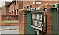
Annadale Terrace sign, Belfast
Tiled sign, mounted on a concrete post, at the Annadale Crescent end of Annadale Terrace - visible (middle left) in Image – March 2010.
Image: © Albert Bridge
Taken: 8 Mar 2012
0.02 miles
4
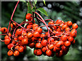
Rowan berries, Belfast
There is a line of rowans, along the Lagan at the Annadale Embankment, between the Governor’s Bridge and Annadale Avenue, all currently producing enough berries to feed the local blackbirds over the winter. This crop is close to the bridge.
Image: © Albert Bridge
Taken: 20 Jul 2011
0.03 miles
5
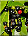
Laurel berries, Belfast
Berries, on a laurel growing between the Annadale Embankment Image and the Lagan, near the Governor’s Bridge. They have a passing resemblance to cherries but contain a toxin which makes them unsuitable for human consumption. Image shows the unripe (green) berries. See also Image
Image: © Albert Bridge
Taken: 15 Sep 2010
0.04 miles
6
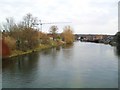
The Lagan at Stranmillis
Looking south from the Governor's Bridge between Annadale and Stranmillis.
Image: © Dean Molyneaux
Taken: 10 Mar 2010
0.04 miles
7
The Annadale Embankment, Belfast (4)
See Image (November 2009). A wet Annadale Embankment approaching the Governor’s Bridge. The overnight rain was the first significant rainfall for about two months.
Image: © Albert Bridge
Taken: 7 Sep 2013
0.04 miles
8
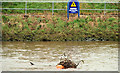
Debris on the Lagan, Belfast
See Image Belfast escaped the worst of yesterday’s weather of heavy snow (especially here Image and Image where there were drifts up to five feet deep). Instead there was heavy/torrential rain and strong to gale force north easterly winds throughout the day and well into the night. Some debris had accumulated on the Lagan, upstream of the governor’s Bridge and had been marked by a high-visibility float (rowers use this stretch). Continue to Image
Image: © Albert Bridge
Taken: 31 Mar 2010
0.04 miles
9
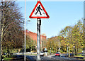
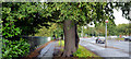
"Zebra crossing" sign, Belfast (November 2014)
A “zebra crossing” ahead sign, on the Annadale Embankment, approaching the Governor’s Bridge where there are three Image (due to the one-way system there).
Image: © Albert Bridge
Taken: 7 Nov 2014
0.04 miles
10
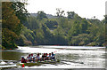
Rowing on the Lagan, Belfast
Rowing is a common sight along the Lagan, on a Saturday morning. The view is upstream from the pontoon at the Governor’s Bridge.
Image: © Albert Bridge
Taken: 22 May 2010
0.04 miles