IMAGES TAKEN NEAR TO
St. Judes Parade, BELFAST, BT7 2HN
Introduction
This page details the photographs taken nearby to St. Judes Parade, BT7 2HN by members of the Geograph project.
The Geograph project started in 2005 with the aim of publishing, organising and preserving representative images for every square kilometre of Great Britain, Ireland and the Isle of Man.

There are currently over 7.5m images from over14,400 individuals and you can help contribute to the project by visiting https://www.geograph.org.uk
Image Map
Images are licensed for reuse under creativecommons.org/licenses/by-sa/2.0
Notes
- Clicking on the map will re-center to the selected point.
- The higher the marker number, the further away the image location is from the centre of the postcode.
Image Listing (145 Images Found)
Images are licensed for reuse under creativecommons.org/licenses/by-sa/2.0
Image
Details
Distance
1
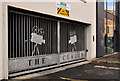
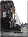
The "Curzon" gates, Belfast
The “Curzon” cinema, on the Ormeau Road, was a contemporary of the “Strand” Image (and others). It closed in 1999. The building lingered until 2003 when it was demolished before being replaced by housing association apartments. This ornamental gate is on the St Jude’s Parade Image side.
Image: © Albert Bridge
Taken: 17 Sep 2011
0.02 miles
2
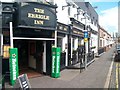
The main entrance into The Errigle Inn, Jameson Street
This well-known Belfast public house stands on the corner of Ormeau Road and Jameson Street.
Image: © Eric Jones
Taken: 27 Apr 2012
0.02 miles
3
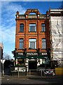
Pavilion Bar, Belfast
A fine bar on the Ormeau Road, Belfast. See http://www.lavs.co.uk/thepavilion/index.asp for more information.
Image: © Rossographer
Taken: 28 Jan 2008
0.03 miles
4
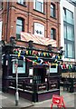
Lavery's Pavilion Bar on the corner of Ormeau Road and St Jude's Parade
Image: © Eric Jones
Taken: 27 Apr 2012
0.03 miles
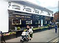
5
The Pavilion Bar, at the junction of Middle Ormeau Road and St Jude's Parade
This traditional pub is also known as the Big House. At its rear from 1867 to 2000 was the Ormeau Cricket Club, the home of the Northern Ireland Cricket Club. All four home nations played here at various times. However, arson attacks led to its abandonment by the cricketers and the field is now used for football. The field is now known as the Ulidia Playing Field.
http://en.wikipedia.org/wiki/Ormeau_Cricket_Ground
Image: © Eric Jones
Taken: 17 Feb 2015
0.03 miles
6
St Jude's Parade, Ballynafeigh
The building on the right which faces on to the Ormeau Road is the Pavilion Bar which used to be the watering hole of members North of Ireland Cricket Club whose grounds were behind the building on the left. The cricket club moved out of the area in 2001.
Image: © Eric Jones
Taken: 10 Jul 2015
0.03 miles
7
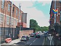
Ulidia Playing Fields
The Ulidia Playing Fields were formerly the Ormeau Cricket ground of the North of Ireland C.C. http://csnicc.com/north/index.asp In 1921 it hosted its first first class international game - that between Ireland and Wales. With a largely middle class Protestant membership the club based as it was in a working-class republican neighbourhood became a target for arsonists and decided in 2001 to withdraw from the area. The fields were then taken over by the Belfast City Council and converted into football pitches.
Image: © Eric Jones
Taken: 10 Jul 2015
0.04 miles
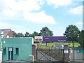
9
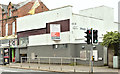
Nos 423-427 Ormeau Road, Belfast (April 2018)
The sign advises that the premises are suitable for refurbishment or redevelopment.
Image: © Albert Bridge
Taken: 13 Apr 2018
0.05 miles
10
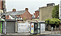
Nos 423-427 Ormeau Road, Belfast (October 2019)
Now demolished.
Image: © Albert Bridge
Taken: 5 Oct 2019
0.05 miles