IMAGES TAKEN NEAR TO
Cooke Mews, BELFAST, BT7 2EY
Introduction
This page details the photographs taken nearby to Cooke Mews, BT7 2EY by members of the Geograph project.
The Geograph project started in 2005 with the aim of publishing, organising and preserving representative images for every square kilometre of Great Britain, Ireland and the Isle of Man.

There are currently over 7.5m images from over14,400 individuals and you can help contribute to the project by visiting https://www.geograph.org.uk
Image Map
Images are licensed for reuse under creativecommons.org/licenses/by-sa/2.0
Notes
- Clicking on the map will re-center to the selected point.
- The higher the marker number, the further away the image location is from the centre of the postcode.
Image Listing (376 Images Found)
Images are licensed for reuse under creativecommons.org/licenses/by-sa/2.0
Image
Details
Distance
1
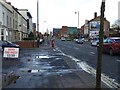
Shaftesbury Avenue, Belfast
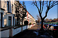
A street, of late 19th century houses, running off the Ormeau Road towards the Lagan (far distance). Just about visible (to the right of the tree) are new Clanmill houses being built on the site of the former North rugby ground. See also Image
Image: © Albert Bridge
Taken: 30 Nov 2010
0.02 miles
2
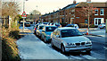
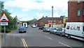
Cooke Street, Belfast
Cooke Street was completed before 1880 and ran from the Ormeau Road towards the Lagan (background). Today’s Sraid Cooke/Cooke Street is the redeveloped version on the same line. Cooke Mews/Eachlann Cooke is on the right. This scene was standard throughout Belfast today. Just about any street, not on a main road and not receiving direct sunlight had a coating of treacherous ice which made walking next to impossible for many.
Image: © Albert Bridge
Taken: 30 Nov 2010
0.02 miles
3
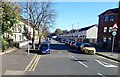
Shaftesbury Avenue off the Lower Ormeau Road
This is a Nationalist area of Belfast.
Image: © Eric Jones
Taken: 15 Oct 2018
0.03 miles
4
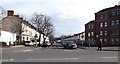
Shaftesbury Avenue, off the Lower Ormeau Road
Image: © Eric Jones
Taken: 17 Feb 2015
0.03 miles
5
Ormeau Road, Belfast
Heading NNW towards Cromack Street
Image: © Kenneth Allen
Taken: 23 Nov 2009
0.05 miles
6
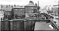
View of what used to be Lavinia Street
Taken in 1973, Lavinia Street was off Ormeau Road nearly opposite McClure Street
Image: © Rob Taylor
Taken: 24 Aug 1973
0.05 miles
8
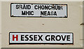
Signs, Essex Grove, Belfast
In English the street takes its name from either the English county or
Robert Devereux, 2nd Earl of Essex, the Elizabethan Lieutenant and Governor General of Ireland.
In Irish the origin is Mac Nissi of Connor – a sixth century bishop.
The red “H” is the logo of the Helm Housing Association Image
Image: © Albert Bridge
Taken: 6 Dec 2009
0.05 miles
9
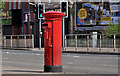
Pillar box, Belfast
GR pillar box, on the Ormeau Road, at the corner of Essex Grove Image
Image: © Albert Bridge
Taken: 24 Jul 2011
0.05 miles
10
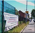
Banner on Lower Ormeau Road publicizing education provision through the medium of Irish
Lower Ormeau Road, north of the Ormeau Bridge, is a strongly Nationalist area. Scoil an Droichid in nearby Cooke Street provides Irish Medium education for some 150 children at nursery, pre-school and primary levels.
http://www.scoilandroichid.com/irish-news/
Image: © Eric Jones
Taken: 30 Jun 2015
0.06 miles