IMAGES TAKEN NEAR TO
Agincourt Street, BELFAST, BT7 1RB
Introduction
This page details the photographs taken nearby to Agincourt Street, BT7 1RB by members of the Geograph project.
The Geograph project started in 2005 with the aim of publishing, organising and preserving representative images for every square kilometre of Great Britain, Ireland and the Isle of Man.

There are currently over 7.5m images from over14,400 individuals and you can help contribute to the project by visiting https://www.geograph.org.uk
Image Map
Images are licensed for reuse under creativecommons.org/licenses/by-sa/2.0
Notes
- Clicking on the map will re-center to the selected point.
- The higher the marker number, the further away the image location is from the centre of the postcode.
Image Listing (351 Images Found)
Images are licensed for reuse under creativecommons.org/licenses/by-sa/2.0
Image
Details
Distance
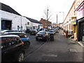
1
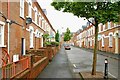
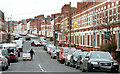
Agincourt Street, Belfast
Part of an area of houses of multiple occupation, Agincourt Street runs from Agincourt Avenue to Rugby Avenue (background). It was built towards the end of the 19th century.
Image: © Albert Bridge
Taken: 26 Aug 2009
0.01 miles
2
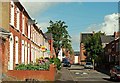
Penrose Street, Belfast
A late 19th century street running from Agincourt Avenue to Rugby Avenue (background).
Image: © Albert Bridge
Taken: 22 Aug 2009
0.02 miles
3
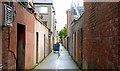
Long back entry, Belfast
A long entry running from Carmel Street, past five other streets, to Agincourt Street. See also Image
Image: © Albert Bridge
Taken: 26 Aug 2009
0.02 miles
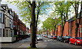
4
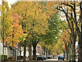
Autumn trees, Rugby Avenue, Belfast (October 2019)
A variety of autumn colours, along Rugby Avenue Image, on a wet but relatively mild October morning.
Image: © Albert Bridge
Taken: 13 Oct 2019
0.03 miles
5
Agincourt Avenue, Belfast (2)
See Image The view from the Ormeau Road. Two points of interest. There are no waiting/parking restrictions and there is a busy Asian supermarket (out of picture to the lower left) which explains the man with the pallet trolley.
Image: © Albert Bridge
Taken: 23 Mar 2010
0.03 miles
6
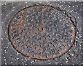
Brett Martin inspection cover, Belfast
A Brett Martin http://www.brettmartin.com/ inspection cover, in Rugby Avenue, between the Ormeau Road and Dudley Street.
Image: © Albert Bridge
Taken: 24 Jul 2011
0.03 miles
7
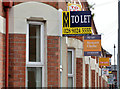
"To let" signs, Belfast (2013)
See Image (July 2010). With the start of the university term approaching there is a proliferation of “to let” signs in and around Agincourt Avenue – a popular area for students.
.
Image: © Albert Bridge
Taken: 23 Aug 2013
0.04 miles
8
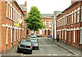
Cadogan Street, Belfast
See Image Not strictly part of the “Holy Land”, Cadogan Street is part of the “holy land” Image area. The view is towards Agincourt Avenue.
Image: © Albert Bridge
Taken: 1 Sep 2009
0.04 miles
10
Rugby Avenue, Belfast
Rugby Avenue runs from College Park Avenue Image to the Ormeau Road. It dates from the late 19th century was originally home to people in clerical etc employment. Now mainly houses of multiple occupation. This is the Ormeau Road end with the trees just in leaf. Continue to Image (September 2013).
Image: © Albert Bridge
Taken: 30 Apr 2010
0.04 miles