IMAGES TAKEN NEAR TO
Curzon Street, BELFAST, BT7 1QU
Introduction
This page details the photographs taken nearby to Curzon Street, BT7 1QU by members of the Geograph project.
The Geograph project started in 2005 with the aim of publishing, organising and preserving representative images for every square kilometre of Great Britain, Ireland and the Isle of Man.

There are currently over 7.5m images from over14,400 individuals and you can help contribute to the project by visiting https://www.geograph.org.uk
Image Map
Images are licensed for reuse under creativecommons.org/licenses/by-sa/2.0
Notes
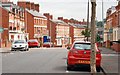
- Clicking on the map will re-center to the selected point.
- The higher the marker number, the further away the image location is from the centre of the postcode.
Image Listing (332 Images Found)
Images are licensed for reuse under creativecommons.org/licenses/by-sa/2.0
Image
Details
Distance
1
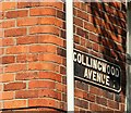
Street sign, Belfast
What seems to be a sign with welded letters, at the southern end of Collingwood Avenue Image The old postal district “7” (now “BT7”) has been painted on.
Image: © Albert Bridge
Taken: 22 Aug 2009
0.01 miles
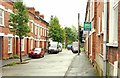
2
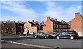
Residential streets off the Stranmillis Embankment
The streets, which include Cadogan and Curzon Streets are on the edge of Belfast's Holy Land (i.e. an area where the streets are all named after Biblical place names e.g. Jerusalem Street)
Image: © Eric Jones
Taken: 17 Feb 2015
0.02 miles
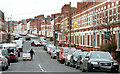
3
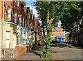
Collingwood Avenue, Belfast
Not strictly part of “Holy Land” Image, Collingwood Avenue is part of the “holy land” area. The view is towards Agincourt Avenue. Many of the houses have “to let” signs in preparation for the start of the university term. It too seems to date from the late 19th century. See also Image
Image: © Albert Bridge
Taken: 22 Aug 2009
0.02 miles
4
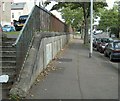
Stranmillis Embankment
Footpath along Stranmillis Embankment http://www.geograph.org.uk/search.php?i=8361900, looking towards the Ormeau Road. The steps on the left lead up to streets in the "holy land" area of Belfast http://www.geograph.org.uk/search.php?i=8361985 .
Image: © Rossographer
Taken: 1 Oct 2009
0.02 miles
5
Curzon Street, Belfast
See Image Not strictly part of the “Holy Land”, Curzon Street is part of the “holy land” area. The view is towards the Stranmillis Embankment. See also Image
Image: © Albert Bridge
Taken: 26 Aug 2009
0.02 miles
6
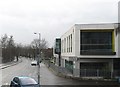
The eastern end of the Stranmillis Embankment
Image: © Eric Jones
Taken: 12 Mar 2011
0.03 miles
7
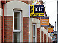
"To let" signs, Belfast (2013)
See Image (July 2010). With the start of the university term approaching there is a proliferation of “to let” signs in and around Agincourt Avenue – a popular area for students.
.
Image: © Albert Bridge
Taken: 23 Aug 2013
0.03 miles
8
Agincourt Avenue, Belfast (2)
See Image The view from the Ormeau Road. Two points of interest. There are no waiting/parking restrictions and there is a busy Asian supermarket (out of picture to the lower left) which explains the man with the pallet trolley.
Image: © Albert Bridge
Taken: 23 Mar 2010
0.04 miles
9
Agincourt Avenue, Belfast
Running from Rugby Road to the Ormeau Road, Agincourt Avenue developed towards the end of the 19th century. Now one of the main thoroughfares in an area mainly comprising houses of multiple occupation. This is the Ormeau Road end from near Carmel Street. Continue to Image
Image: © Albert Bridge
Taken: 16 Jun 2009
0.04 miles
10
Cadogan Street, Belfast
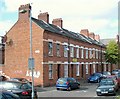
Short street of terraced housing in the "holy land" area of Belfast. Most of the houses are now rentals, mainly catering for students. See also Image
Image: © Rossographer
Taken: 1 Oct 2009
0.04 miles