IMAGES TAKEN NEAR TO
Southview Street, BELFAST, BT7 1PZ
Introduction
This page details the photographs taken nearby to Southview Street, BT7 1PZ by members of the Geograph project.
The Geograph project started in 2005 with the aim of publishing, organising and preserving representative images for every square kilometre of Great Britain, Ireland and the Isle of Man.

There are currently over 7.5m images from over14,400 individuals and you can help contribute to the project by visiting https://www.geograph.org.uk
Image Map
Images are licensed for reuse under creativecommons.org/licenses/by-sa/2.0
Notes
- Clicking on the map will re-center to the selected point.
- The higher the marker number, the further away the image location is from the centre of the postcode.
Image Listing (335 Images Found)
Images are licensed for reuse under creativecommons.org/licenses/by-sa/2.0
Image
Details
Distance
1
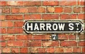
Harrow Street, Belfast (2)
See Image Whatever the origins of Harrow Street, it retains this cast street sign at the Southview Street end. Such signs are not too common. The question is “Does BT7 have a greater variety of street-name (and terrace name) signs than any other postal district in Belfast?”.
Image: © Albert Bridge
Taken: 16 Jun 2009
0.02 miles
2
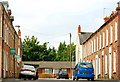
Harrow Street, Belfast (1)
In Image I referred to the 20th century redevelopment which obliterated some streets, truncated others and retained some in name only. Frustrating for the casual genealogist and local historian but nothing new.
Harrow Street now runs from Carmel Street Image to Southview Street Image (background). It was built circa 1878/80 when it was described as running from Crecy Terrace – a name now unknown. Further a map from the early 1860’s shows this area as devoid of houses. See also Image
Image: © Albert Bridge
Taken: 16 Jun 2009
0.02 miles
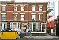
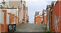
3
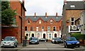
Southview Street, Belfast
Southview Street runs off Harrow Street Image but has a less complicated history. A street from the late 19th century with a few recent additions (out of picture to the left). The view is to Agincourt Avenue.
Image: © Albert Bridge
Taken: 1 Sep 2009
0.02 miles
4
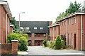
Rugby Court, Belfast
Townhouses and apartments built on the site of what was once Alma Cottage and Gordon Terrace, Agincourt Avenue.
Image: © Albert Bridge
Taken: 1 Sep 2009
0.02 miles
5
Retained housefronts, Belfast
The retained façades of nos 142 and 144 Agincourt Avenue. Work is in progress behind.
Image: © Albert Bridge
Taken: 1 Sep 2009
0.03 miles
6
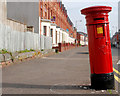
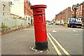
Victorian pillar box, Belfast (2)
See Image The same pillar box in Agincourt Avenue – now with a fresh coat of paint and a “wet paint” sign”. Continue to Image
Image: © Albert Bridge
Taken: 9 Apr 2011
0.03 miles
7

Victorian pillar box, Belfast (3)
See Image The inscription on the base showing that it was made by A Handyside & Co Ltd (Derby and London). This link http://www.geograph.org.uk/search.php?i=20587343 shows other examples of the company’s products.
Image: © Albert Bridge
Taken: 9 Apr 2011
0.03 miles
8
Victorian pillar box, Belfast (1)
An out-of-true VR pillar box, in Agincourt Avenue close to the corner of Rugby Road. The notice plate is missing. Continue to Image
Image: © Albert Bridge
Taken: 18 Jul 2009
0.03 miles
9
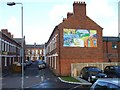
Cadogan Street, Belfast
On the gable wall is a "Welcome" mural written in various languages
Image: © Kenneth Allen
Taken: 23 Nov 2009
0.04 miles
10
Lane, Belfast
Technically it’s probably an entry but much wider than the standard of the area Image It runs from the Stranmillis Embankment to Agincourt Avenue.
Image: © Albert Bridge
Taken: 1 Sep 2009
0.04 miles