IMAGES TAKEN NEAR TO
Maryville Court, BELFAST, BT7 1PF
Introduction
This page details the photographs taken nearby to Maryville Court, BT7 1PF by members of the Geograph project.
The Geograph project started in 2005 with the aim of publishing, organising and preserving representative images for every square kilometre of Great Britain, Ireland and the Isle of Man.

There are currently over 7.5m images from over14,400 individuals and you can help contribute to the project by visiting https://www.geograph.org.uk
Image Map
Images are licensed for reuse under creativecommons.org/licenses/by-sa/2.0
Notes
- Clicking on the map will re-center to the selected point.
- The higher the marker number, the further away the image location is from the centre of the postcode.
Image Listing (1336 Images Found)
Images are licensed for reuse under creativecommons.org/licenses/by-sa/2.0
Image
Details
Distance
1
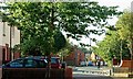
Maryville Street, Belfast (2)
See Image The view in the opposite direction – from the Bankmore Street/Ormeau Avenue end. Continue to Image
Image: © Albert Bridge
Taken: 25 Aug 2009
0.01 miles
2
Lindsay Street, Belfast (2)
See Image Until about the late 1860’s this area was vacant ground crossed by a stream (now culverted) feeding into the Blackstaff River. The view is from Maryville Street towards Charlotte Street Image
Image: © Albert Bridge
Taken: 25 Aug 2009
0.03 miles
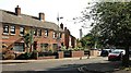
3
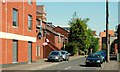
Apsley Street, Belfast
The original Apsley Street ran from Donegall Pass, across Bankmore Street, to Ormeau Avenue. Today’s redeveloped version still does but is no longer a through route for vehicles. The view is from the Bankmore Street end towards Donegall Pass.
Image: © Albert Bridge
Taken: 25 Oct 2009
0.05 miles
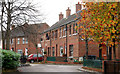
4
Salisbury Street, Belfast
The area to the east of the Dublin Road saw widespread redevelopment in the 1980’s. Salisbury Street (foreground) and Maryville Street were rebuilt on the sites of the old streets. There is greenery now where there was none before.
Image: © Albert Bridge
Taken: 9 Jun 2009
0.05 miles
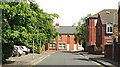
5
Sewer improvements, Belfast - June 2018(1)
Work is continuing, hidden from public view, at several places. This crane is between Maryville Street and Hardcastle Street (background).
Image: © Albert Bridge
Taken: 17 Jun 2018
0.05 miles
6
Lindsay Street, Belfast
The original Lindsay Street ran from the Ormeau Road to Craigmore Street and had more than 100 houses. Today’s street is a shorter version running from Charlotte Street Image (where I am standing) to Maryville Street. See also Image
Image: © Albert Bridge
Taken: 31 May 2009
0.06 miles
7
Salisbury Court, Belfast
Salisbury Court (between Salisbury Street and Hartington Street) off the Dublin Road was built in the 80’s (as part of a larger scheme) replacing old small terraced houses.
Image: © Albert Bridge
Taken: 23 Sep 2007
0.06 miles
8
Maryville Street, Belfast
Maryville Street still runs from Donegall Pass Image to Ormeau Avenue Image but was re-built in the 80’s with a mix of public and private-sector houses and apartments. The view is from Conduit Street on the other side of Donegall Pass. Continue to Image
Image: © Albert Bridge
Taken: 31 May 2009
0.06 miles
9
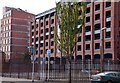
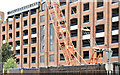
Hardcastle Street, Belfast
On the left is the former Somerset’s linen factory built in 1904 and thought to be the first reinforced-concrete framed building in Ireland. After lying vacant for a number of years it was converted to Somerset Studios at the time when “loft living” was fashionable. On the right is the multi-storey car park behind the multiplex cinema on the Dublin Road. (Note for concrete enthusiasts - it was the “Hennebique system”).
Image: © Albert Bridge
Taken: 28 Oct 2007
0.06 miles
10
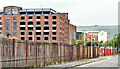
Bankmore Street, Belfast (June 2017)
See Image (December 2013). Bankmore Street looking towards the Dublin Road. The One Bankmore Square development, if it proceeds in the form currently envisaged, will be prominent in the area to the right of the multi-storey car park.
Image: © Albert Bridge
Taken: 11 Jun 2017
0.06 miles