IMAGES TAKEN NEAR TO
Lower Crescent, BELFAST, BT7 1NR
Introduction
This page details the photographs taken nearby to Lower Crescent, BT7 1NR by members of the Geograph project.
The Geograph project started in 2005 with the aim of publishing, organising and preserving representative images for every square kilometre of Great Britain, Ireland and the Isle of Man.

There are currently over 7.5m images from over14,400 individuals and you can help contribute to the project by visiting https://www.geograph.org.uk
Image Map (1053 Images)


Leaflet Map data © OpenStreetMap
Images are licensed for reuse under creativecommons.org/licenses/by-sa/2.0
Notes
- Clicking on the map will re-center to the selected point.
- The higher the marker number, the further away the image location is from the centre of the postcode.
Image Listing (1053 Images Found)
Images are licensed for reuse under creativecommons.org/licenses/by-sa/2.0
Image
Details
Distance
1
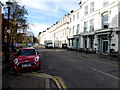
Lower Crescent, Belfast
Heading WSW from Botanic Avenue to University Road
Image: © Kenneth Allen
Taken: 7 Nov 2017
0.01 miles
2
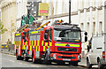
Fire appliances, Belfast
Two appliances, at Lower Crescent, in attendance at what seemed to be a false alarm at Crescent Gardens.
Image: © Albert Bridge
Taken: 2 Oct 2013
0.01 miles
3
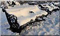
Snow-covered seats, Belfast
Snow-covered seats at the Lower Crescent side of the park opposite Image
Image: © Albert Bridge
Taken: 21 Dec 2010
0.01 miles
4
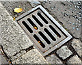
"Patent" grating cover, Belfast (August 2014)
See Image (Grand Parade/Dunraven Park). A similar (but not identical) cover at the Crescent Gardens end of Upper Crescent.
Image: © Albert Bridge
Taken: 27 Aug 2014
0.01 miles
5
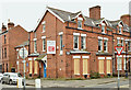
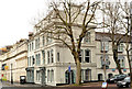
Vacant office building, Lower Crescent, Belfast (March 2016)
A vacant building, at the corner of Lower Crescent and Crescent Gardens, currently offered for sale. Originally a house and possibly built at the end of the 19th century.
Image: © Albert Bridge
Taken: 13 Mar 2016
0.01 miles
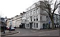
6
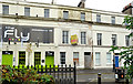
No 7 Lower Crescent, Belfast (1)
No 7 Lower Crescent is currently advertised “for sale”. The agents’ description includes the following: “The subject property benefits from full planning permission (granted 11 September 2008) to convert the existing accommodation to a licensed premises, to include demolition of the rear return and rebuild with the retention of the existing facade onto Lower Crescent (Application No. /2007/2076/F)”.
The building, which seems to be in a poor state of repair, is listed http://www.doeni.gov.uk/niea/built/buildview?id=2593&js=true. The list comments “Relatively large three storey rendered town house, one of regency style terrace of eleven similar, (but not identical) properties built in 1852 and now converted to offices, flats and a public house”.
This photograph appears as a matter of record only. I have no connection with any of the parties involved in the sale and express no views about the approval to demolish. See also Image
Image: © Albert Bridge
Taken: 14 Oct 2012
0.02 miles
7
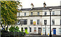
No 7 Lower Crescent, Belfast (2)
See Image No 7 Lower Crescent seen from Crescent Gardens.
Image: © Albert Bridge
Taken: 14 Oct 2012
0.02 miles
8
The Crescent Townhouse hotel, Belfast
The Crescent Townhouse hotel http://crescenttownhouse.com/ at the corner of Lower Crescent and Botanic Avenue (foreground). Part of a long terrace built between 1846 and 1852 for one of the Corry family http://www.geograph.org.uk/search.php?i=47506551 – different sources quote different members. Once known as “The Regency”. The photograph appears as a matter of record only. I have no connection with the hotel.
Image: © Albert Bridge
Taken: 9 Mar 2014
0.02 miles
9
Best Western Crescent Hotel at the junction of Lower Crescent and Botanic Avenue
Image: © Eric Jones
Taken: 17 Feb 2015
0.02 miles
10
Botanic station, Belfast
Botanic station opened in 1976 on the re-opening of the line built by the Belfast Central Railway in 1874/76 and closed in 1965 by the UTA. The line is below street level. The station is fairly basic comprising two platforms and a booking office. Image shows the station as built.
Image: © Albert Bridge
Taken: 25 Nov 2007
0.02 miles