IMAGES TAKEN NEAR TO
University Street, BELFAST, BT7 1FY
Introduction
This page details the photographs taken nearby to University Street, BT7 1FY by members of the Geograph project.
The Geograph project started in 2005 with the aim of publishing, organising and preserving representative images for every square kilometre of Great Britain, Ireland and the Isle of Man.

There are currently over 7.5m images from over14,400 individuals and you can help contribute to the project by visiting https://www.geograph.org.uk
Image Map
Images are licensed for reuse under creativecommons.org/licenses/by-sa/2.0
Notes
- Clicking on the map will re-center to the selected point.
- The higher the marker number, the further away the image location is from the centre of the postcode.
Image Listing (1077 Images Found)
Images are licensed for reuse under creativecommons.org/licenses/by-sa/2.0
Image
Details
Distance
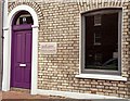
1
Doorway, south Belfast (2)
See Image No 23 has sash windows and a traditional doorway. The windows on the right are part of no 25. Continue to Image
Image: © Albert Bridge
Taken: 15 Feb 2009
0.01 miles
2
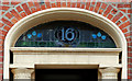
Fanlight, Belfast (3)
The fanlight of no 16 University Square – this part of the square was built in 1848-53. Unlike its near neighbour Image this one includes some stained glass. Continue to Image
Image: © Albert Bridge
Taken: 29 Nov 2009
0.03 miles
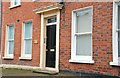
3
Doorway, south Belfast (1)
The southern side of University Street has a variety of doorways including Image No 13 is an good example of how to blend a modern door and window with a Victorian building. Continue to Image
Image: © Albert Bridge
Taken: 15 Feb 2009
0.03 miles
4
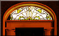
Fanlight, Belfast (4)
See Image The fanlight of no 10 University Square includes some attractive stained glass.
Image: © Albert Bridge
Taken: 11 Dec 2009
0.03 miles
5
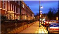
University Square, Belfast (3)
The view, at twilight, along University Square Image towards Botanic Avenue.
Image: © Albert Bridge
Taken: 22 Dec 2008
0.03 miles
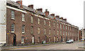
6
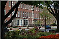
University Square (northern side). Belfast
As Belfast expanded during the middle of the nineteenth century its middle class sought suitable accommodation away from the linen mills and engineering works which provided the basis for their wealth. South Belfast experienced much desirable development. The area around what is now Queens University became particularly fashionable. The houses in the photograph were built between 1848 and 1853. They are now occupied by various departments of the university.
Image: © Albert Bridge
Taken: 7 May 2006
0.03 miles
7
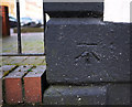
Bench Mark, Belfast
Cut bench mark on a wall by the corner of University Street Mews & University Street in Belfast.
See also http://www.geograph.org.uk/search.php?i=11037856 for many other examples I have found.
Image: © Rossographer
Taken: 2 Mar 2010
0.03 miles
8
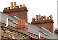
Row, University Street, Belfast - April 2014(2)
Chimneys and chimney pots of various ages, designs and sizes on the Mount Charles buildings.
Image: © Albert Bridge
Taken: 6 Apr 2014
0.04 miles
9
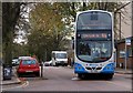
The "Uni-Link" bus, Belfast
Ulsterbus “Uni-Link” service 163A connects Queen’s University, Belfast and the University of Ulster at Jordanstown, Newtownabbey – a 25 minute journey. A recently-delivered Wright-bodied Volvo is leaving the Belfast terminus, in Botanic Avenue, with the 11.30 service.
Image: © Albert Bridge
Taken: 18 Oct 2007
0.04 miles
10
Row, University Street, Belfast - April 2014(1)
The entire row seen from close to the University Road.
Image: © Albert Bridge
Taken: 6 Apr 2014
0.04 miles