IMAGES TAKEN NEAR TO
Virginia Way, BELFAST, BT7 1DF
Introduction
This page details the photographs taken nearby to Virginia Way, BT7 1DF by members of the Geograph project.
The Geograph project started in 2005 with the aim of publishing, organising and preserving representative images for every square kilometre of Great Britain, Ireland and the Isle of Man.

There are currently over 7.5m images from over14,400 individuals and you can help contribute to the project by visiting https://www.geograph.org.uk
Image Map
Images are licensed for reuse under creativecommons.org/licenses/by-sa/2.0
Notes
- Clicking on the map will re-center to the selected point.
- The higher the marker number, the further away the image location is from the centre of the postcode.
Image Listing (996 Images Found)
Images are licensed for reuse under creativecommons.org/licenses/by-sa/2.0
Image
Details
Distance
1
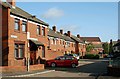
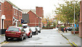
Virginia Way, Belfast
A street off Vernon Street Image Built on part of the line of Virginia Street, the remainder of which survives (re-built) at the far end, through to Donegall Pass.
Image: © Albert Bridge
Taken: 25 Aug 2009
0.02 miles
2
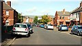
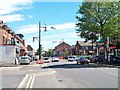
Vernon Street, Belfast
Vernon Street seems to have been built around 1870 as a street of standard Belfast terrace houses, one side of which backed onto the Belfast Central railway – then a goods line connecting the GNR(I) to the Belfast and County Down Railway and Belfast harbour. Now completely re-built and unrecognisable. The view is towards Donegall Pass.
Image: © Albert Bridge
Taken: 25 Aug 2009
0.03 miles
3
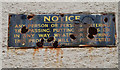
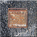
Rusty sign, Belfast
A rusty sign, on a wall in Elm Street Image off Donegall Pass.
Image: © Albert Bridge
Taken: 25 Oct 2009
0.04 miles
4
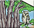
Owl and tree wall art, Belfast (May 2018)
An owl in a tree wall/street art at the Donegall Pass Community Garden, Conduit Street. Not as fanciful as it might seem. The Pass was once the site of Cromac Wood. See also Image
Image: © Albert Bridge
Taken: 6 May 2018
0.04 miles
5
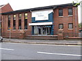
Elim Pentecostal Church on the corner of Donegall Pass and Virginia Way
Elim Pentecostal Church was founded in Co Monaghan in 1915 by a Welshman, Pastor George Jeffreys of Nantyffylon, Maesteg. The denomination has a number of churches in Ulster, including in the city of Belfast.
Image: © Eric Jones
Taken: 19 May 2012
0.04 miles
6
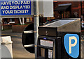
Solar panel, Belfast (3)
A small solar panel, powering a parking meter, at a car park in Posnett Street.
Image: © Albert Bridge
Taken: 25 Mar 2012
0.05 miles
8
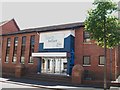
South Belfast Elim Pentecostal Church, Donegall Pass
This is a recently completed building.
http://www.churchdesign.co.uk/work/donegal-pass-elim-church/
Image]
Image: © Eric Jones
Taken: 30 Jun 2015
0.05 miles
9
Elm Street, Belfast
Elm Street runs parallel to Donegall Pass to the south. Many of the streets were named after trees but some did not survive redevelopment.
Image: © Albert Bridge
Taken: 25 Oct 2009
0.05 miles
10
Monitoring well cover, Belfast
See Image Another example from Stuart Well Services http://www.stuartgroup.ltd.uk/wellservices/index.php , this is located on Platform 2 of Botanic Railway Station in Belfast (just visible on the left in Image).
Image: © Rossographer
Taken: 11 Oct 2013
0.05 miles