IMAGES TAKEN NEAR TO
Erin Way, BELFAST, BT7 1AZ
Introduction
This page details the photographs taken nearby to Erin Way, BT7 1AZ by members of the Geograph project.
The Geograph project started in 2005 with the aim of publishing, organising and preserving representative images for every square kilometre of Great Britain, Ireland and the Isle of Man.

There are currently over 7.5m images from over14,400 individuals and you can help contribute to the project by visiting https://www.geograph.org.uk
Image Map
Images are licensed for reuse under creativecommons.org/licenses/by-sa/2.0
Notes
- Clicking on the map will re-center to the selected point.
- The higher the marker number, the further away the image location is from the centre of the postcode.
Image Listing (1097 Images Found)
Images are licensed for reuse under creativecommons.org/licenses/by-sa/2.0
Image
Details
Distance
1
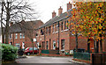
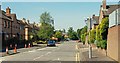
Apsley Street, Belfast
The original Apsley Street ran from Donegall Pass, across Bankmore Street, to Ormeau Avenue. Today’s redeveloped version still does but is no longer a through route for vehicles. The view is from the Bankmore Street end towards Donegall Pass.
Image: © Albert Bridge
Taken: 25 Oct 2009
0.02 miles
2
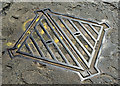
"Broads" GPO access cover, Belfast - April 2016(1)
A “Broads” access cover at Bankmore Street. It carries the inscription “GPO” (abolished in 1969) and the trade name “Silent Knight”. Image shows part of the inscription.
Image: © Albert Bridge
Taken: 30 Apr 2016
0.03 miles
3
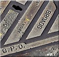
"Broads" GPO access cover, Belfast - April 2016(2)
See Image A detail from the corner showing the inscription “GPO” (abolished in 1969), the foundry name and part of the trade name “Silent Knight”.
Image: © Albert Bridge
Taken: 30 Apr 2016
0.03 miles
4
Bankmore Street, Belfast (2013)
See Image (October 2007). The view along Bankmore Street, towards the Dublin Road, from close to Ormeau Avenue. The street forms part of a reserved line for a proposed inner ring road (the Bankmore Link) which seems unlikely to proceed as originally envisaged. In common with any area affected by long-term proposals, which never come to fruition, it remains an example of blight.
Image: © Albert Bridge
Taken: 26 Dec 2013
0.03 miles
5
Lindsay Street, Belfast
The original Lindsay Street ran from the Ormeau Road to Craigmore Street and had more than 100 houses. Today’s street is a shorter version running from Charlotte Street Image (where I am standing) to Maryville Street. See also Image
Image: © Albert Bridge
Taken: 31 May 2009
0.04 miles
6
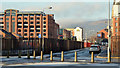
Bankmore Street, Belfast (June 2017)
See Image (December 2013). Bankmore Street looking towards the Dublin Road. The One Bankmore Square development, if it proceeds in the form currently envisaged, will be prominent in the area to the right of the multi-storey car park.
Image: © Albert Bridge
Taken: 11 Jun 2017
0.04 miles
7
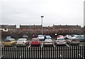
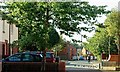
Commutera car park in Ormeau Avenue
Housing in Erin Way form the background.
Image: © Eric Jones
Taken: 15 Feb 2012
0.05 miles
8
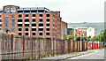
Northern Ireland Fire and Rescue Belfast Central Station, Ormeau Avenue
Image: © Eric Jones
Taken: 12 Mar 2011
0.05 miles
9
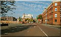
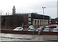
Ormeau Avenue, Belfast
Ormeau Avenue runs from the bottom of the Ormeau Road/Cromac Street to Bedford Street. Much improved (notably by the addition of a “Holiday Inn”), further improvement seems unlikely until a decision is taken not to proceed with the on/off/on etc inner ring road. The vacant ground (middle left, used as a car park) could then be sold for further development.
Image: © Albert Bridge
Taken: 21 Sep 2008
0.05 miles
10
Maryville Street, Belfast (2)
See Image The view in the opposite direction – from the Bankmore Street/Ormeau Avenue end. Continue to Image
Image: © Albert Bridge
Taken: 25 Aug 2009
0.05 miles