IMAGES TAKEN NEAR TO
Omagh Road, DUNGANNON, BT70 2DX
Introduction
This page details the photographs taken nearby to Omagh Road, BT70 2DX by members of the Geograph project.
The Geograph project started in 2005 with the aim of publishing, organising and preserving representative images for every square kilometre of Great Britain, Ireland and the Isle of Man.

There are currently over 7.5m images from over14,400 individuals and you can help contribute to the project by visiting https://www.geograph.org.uk
Image Map
Images are licensed for reuse under creativecommons.org/licenses/by-sa/2.0
Notes
- Clicking on the map will re-center to the selected point.
- The higher the marker number, the further away the image location is from the centre of the postcode.
Image Listing (56 Images Found)
Images are licensed for reuse under creativecommons.org/licenses/by-sa/2.0
Image
Details
Distance
1
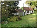
Old farm buildings at Garvaghy
As seen from the Curr Road
Image: © Kenneth Allen
Taken: 17 Oct 2008
0.08 miles
2
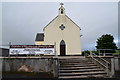
Banner, Garvaghy
Pictured beside St Matthew's RC Church, it says:
Celebration of Education in the Garvaghey Area
All day Saturday 22nd September, 2018
Rarogan National School 1836 - 1928
Garvaghey Primary School
St. Matthew's Primary School 1928 - 2018
Altcloghfin National School - 1928
Note: the official spelling for this townland is Garvaghy
Image: © Kenneth Allen
Taken: 22 Aug 2018
0.09 miles
3
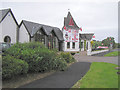
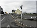
Kelly's Inn
Kelly's Inn is a family run hostelry operating since 1937.
Situated 5 miles from Ballygawley Roundabout on the main Omagh to Ballygawley Road.
Image: © Kenneth Allen
Taken: 2 Oct 2005
0.10 miles
5
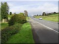
Omagh Road, Garvaghy
Heading north-west to Omagh
Image: © Kenneth Allen
Taken: 17 Oct 2008
0.11 miles
6

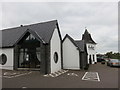
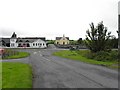
Garvaghy, County Tyrone
The Supermarket, Filling Station, Kelly's Inn and Garvaghy RC Church can be seen ahead, beyond is the townland of Rarogan
Image: © Kenneth Allen
Taken: 24 Nov 2008
0.12 miles
7
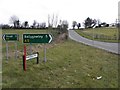
Radergan Road
Heading south-west towards the A5 Omagh to Ballygawley Road
The buildings ahead are Kelly's Inn and St Matthew's RC Church, Garvaghy
Image: © Kenneth Allen
Taken: 11 Aug 2011
0.12 miles
8

BM2029, Garvaghy Primary School
Flush bracket bench mark, it is located here Image
The number on the bracket is OSNIBM 2029.
The mark is 163.68 metres above MSL.
Being excessively covered in paint, it is hard to read
Image: © Kenneth Allen
Taken: 30 Sep 2010
0.13 miles
9
Rarogan Road, Garvaghy
Heading south-west from Omagh Road
Image: © Kenneth Allen
Taken: 1 Mar 2013
0.13 miles
10
Radergan Road, Garvaghy
Heading north-east from Omagh Road
Image: © Kenneth Allen
Taken: 1 Mar 2013
0.13 miles