IMAGES TAKEN NEAR TO
Church Road, BELFAST, BT6 9SA
Introduction
This page details the photographs taken nearby to Church Road, BT6 9SA by members of the Geograph project.
The Geograph project started in 2005 with the aim of publishing, organising and preserving representative images for every square kilometre of Great Britain, Ireland and the Isle of Man.

There are currently over 7.5m images from over14,400 individuals and you can help contribute to the project by visiting https://www.geograph.org.uk
Image Map
Images are licensed for reuse under creativecommons.org/licenses/by-sa/2.0
Notes
- Clicking on the map will re-center to the selected point.
- The higher the marker number, the further away the image location is from the centre of the postcode.
Image Listing (13 Images Found)
Images are licensed for reuse under creativecommons.org/licenses/by-sa/2.0
Image
Details
Distance
1
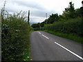
Church Road, Castlereagh
Minor road in Castlereagh.
Image: © Rossographer
Taken: 5 Aug 2008
0.05 miles
2
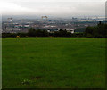
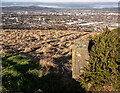
Field above Belfast
Field at Castlereagh offering fantastic views across the northern half of Belfast. Here, the sprawling Belfast docks are most obvious with the yellow cranes 'Samson' and 'Goliath' http://www.geograph.org.uk/search.php?i=3296384 most obvious. If only the weather had been better..........
Image: © Rossographer
Taken: 5 Aug 2008
0.09 miles
3
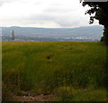
Barley field, Castlereagh
Field of barley in Castlereagh above Belfast (just over the edge of the field beyond).
Image: © Rossographer
Taken: 5 Aug 2008
0.11 miles
4
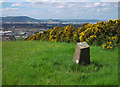
Casaeldona Triangulation Pillar
Triangulation pillar situated in Castlereagh, on the eastern edge of Belfast. The pillar lies in a field accessed off the Church Road. It has been slightly damaged and lies at an angle but is otherwise intact. On a clear day the views over Belfast are excellent. See also Image and Image
Image: © Rossographer
Taken: 2 Jun 2010
0.13 miles
5
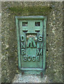
Flush Bracket, Casaeldona Triangulation Pillar
Flush bracket located on the Casaeldona Triangulation Pillar Image
The number on the bracket is OSNIBM 3061.
I cannot find the exact height above MSL for the mark.
A flush bracket is a type of bench mark. See also http://www.geograph.org.uk/search.php?i=11037856 for many other examples I have found.
Image: © Rossographer
Taken: 2 Jun 2010
0.13 miles
6
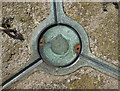
Spider, Casaeldona Triangulation Pillar
Detail on the 'spider' on the Casaeldona Triangulation Pillar Image Note that it is marked
"TRIANGULATION STATION
OSNI".
Image: © Rossographer
Taken: 2 Jun 2010
0.13 miles
7
Casaeldona Triangulation Pillar
Triangulation pillar situated in Castlereagh, on the eastern edge of Belfast. The pillar lies in a field accessed off the Church Road. It has been slightly damaged and lies at an angle but is otherwise intact. On a clear day the views over Belfast are excellent. The gorse bush may overwhelm it in future.
Image: © Rossographer
Taken: 1 Jan 2025
0.13 miles
8
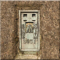
Flush Bracket, Casaeldona Triangulation Pillar
Flush bracket bench mark located on the Casaeldona Triangulation Pillar.
The number on the bracket is OSNIBM 3061.
Image: © Rossographer
Taken: 1 Jan 2025
0.13 miles
9
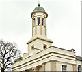
Castlereagh Presbyterian church (bell tower) (April 2017)
See Image (January 2006). The belfry/bell tower. For another detailed description of the church see “Buildings of North County Down” by CEB Brett, Ulster Architectural Heritage Society, 2002 (pages 58/59).
Image: © Albert Bridge
Taken: 20 Apr 2017
0.13 miles
10
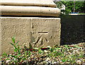
Bench Mark, Castlereagh
Cut bench mark on Castlereagh Presbyterian Church Image
The mark is 134.69 metres above MSL.
Image: © Rossographer
Taken: 2 Jun 2010
0.14 miles