IMAGES TAKEN NEAR TO
Manse Road, BELFAST, BT6 9RT

Introduction

This page details the photographs taken nearby to Manse Road, BT6 9RT by members of the Geograph project.

The Geograph project started in 2005 with the aim of publishing, organising and preserving representative images for every square kilometre of Great Britain, Ireland and the Isle of Man.

There are currently over 7.5m images from over14,400 individuals and you can help contribute to the project by visiting https://www.geograph.org.uk

Image Map


Images are licensed for reuse under creativecommons.org/licenses/by-sa/2.0
Notes
  • Clicking on the map will re-center to the selected point.
  • The higher the marker number, the further away the image location is from the centre of the postcode.

Image Listing (11 Images Found)

Images are licensed for reuse under creativecommons.org/licenses/by-sa/2.0
Image
Details
Distance
1
Castlereagh Presbyterian Church
The Congregation was founded in 1650. The present church building, erected in 1835 was designed by Belfast architect John Millar, in a Greek Revival style and was possibly the second or third building on this site. It was the first Presbyterian church in Ireland to have a bell tower, and its commanding site makes it conspicuous from many parts of the city. The Ionic detail has helped to ensure that the building now has an Historical Listing as 'A Building of Special Architectural and Historic Interest'.
Image: © Brian Shaw Taken: 18 Jan 2006
0.16 miles
2
Bench Mark, Castlereagh
Cut bench mark on Castlereagh Presbyterian Church Image The mark is 134.69 metres above MSL.
Image: © Rossographer Taken: 2 Jun 2010
0.21 miles
3
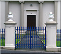
Gates and entrance, Castlereagh Presbyterian Church
Gates and main entrance to Image
Image: © Rossographer Taken: 5 Aug 2008
0.21 miles
4
Churchyard, Castlereagh Presbyterian Church
Churchyard of Image
Image: © Rossographer Taken: 5 Aug 2008
0.22 miles
5
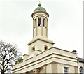
Castlereagh Presbyterian church (bell tower) (April 2017)
See Image (January 2006). The belfry/bell tower. For another detailed description of the church see “Buildings of North County Down” by CEB Brett, Ulster Architectural Heritage Society, 2002 (pages 58/59).
Image: © Albert Bridge Taken: 20 Apr 2017
0.22 miles
6
Gyratory, Ballygowan Road near Belfast (3)
The short link which allows outbound traffic (background) to “turn right” into the Manse Road without the need to stop in a conventional right-turn bay.
Image: © Albert Bridge Taken: 3 Mar 2014
0.22 miles
7
Gyratory, Ballygowan Road near Belfast (2)
The view from the Belfast-bound Ballygowan Road towards the Manse Road (both sides of the car).
Image: © Albert Bridge Taken: 3 Mar 2014
0.22 miles
8
Gyratory, Ballygowan Road near Belfast (5)
The view across towards the Manse Road. The right lane is marked “Belfast only”. The left lane is for all other traffic.
Image: © Albert Bridge Taken: 3 Mar 2014
0.22 miles
9
Gyratory, Ballygowan Road near Belfast (6)
The view from the Manse Road across to the Upper Braniel Road showing the road markings. The old line is on the left.
Image: © Albert Bridge Taken: 3 Mar 2014
0.22 miles
10
Gyratory, Ballygowan Road near Belfast (7)
The road signs at the Ballygowan Road end of the Manse Road (background in Image).
Image: © Albert Bridge Taken: 3 Mar 2014
0.22 miles