IMAGES TAKEN NEAR TO
Alexander Road, BELFAST, BT6 9HJ
Introduction
This page details the photographs taken nearby to Alexander Road, BT6 9HJ by members of the Geograph project.
The Geograph project started in 2005 with the aim of publishing, organising and preserving representative images for every square kilometre of Great Britain, Ireland and the Isle of Man.

There are currently over 7.5m images from over14,400 individuals and you can help contribute to the project by visiting https://www.geograph.org.uk
Image Map
Images are licensed for reuse under creativecommons.org/licenses/by-sa/2.0
Notes
- Clicking on the map will re-center to the selected point.
- The higher the marker number, the further away the image location is from the centre of the postcode.
Image Listing (16 Images Found)
Images are licensed for reuse under creativecommons.org/licenses/by-sa/2.0
Image
Details
Distance
1
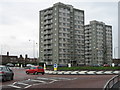
High-rise Accommodation
These flats are situated beside the roundabout at the junction of Cregagh Road with Ladas Drive and Mount Merrion Avenue.
Image: © Brian Shaw
Taken: 18 Jan 2006
0.17 miles
2
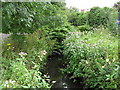
Loop River at Ladas Drive
One of the urban streams in East Belfast. It has become somewhat untidy however allegedly boasts a considerable amount of wildlife.
Image: © Dean Molyneaux
Taken: 9 Jul 2009
0.18 miles
3
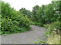
Overgrown Public Park, Ladas Drive
Until the 1980s this was a pleasant park by the Loop River. However it fell into a sharp decline and is now heavily overgrown. The park benches have been removed also.
Image: © Dean Molyneaux
Taken: 9 Jul 2009
0.19 miles
4
Ladas Drive, Belfast
Street running from the Cregagh Road to the Castlereagh Road in east Belfast. Unusually for Belfast, most of the road surface is concrete.
Image: © Rossographer
Taken: 7 Jul 2010
0.19 miles
5
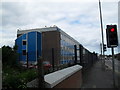
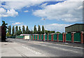
Government Offices, Ladas Drive
83 Ladas Drive - for many years the home of the Ordnance Survey of Northern Ireland. Nowadays it is occupied by the Health and Safety Executive of Northern Ireland (H.S.E.N.I.).
Image: © Dean Molyneaux
Taken: 9 Jul 2009
0.19 miles
6
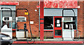
Disused petrol pumps, Belfast
Pumps, at a closed petrol station in Ladas Drive (opposite Orangefield Crescent).
Image: © Albert Bridge
Taken: 10 Aug 2011
0.20 miles
7
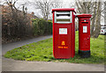
Postboxes, Belfast
Large postbox for franked mail (BT6 421) and George VI pillar box (BT6 719) on Montgomery Road, Belfast.
Image: © Rossographer
Taken: 20 Mar 2017
0.21 miles
8
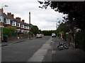
Graham Gardens, Cregagh
Graham Gardens sits just inside the city's municipal boundary and was constructed between 1936 and 1949. The long period can be explained by the effect of WWII - as numbers 17-23 are of a much more austere design. In the early 1990s, a mews development called "The Village Green" was constructed at the far end.
Image: © Dean Molyneaux
Taken: 9 Jul 2009
0.21 miles
9
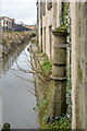
Boundary Post, Belfast
Old parliamentary boundary post overhanging the Loop River behind Ladas Drive in Belfast. See also Image
The inscription reads:
"Parliamentary
and Municipal Boundary of
Belfast
Ormeau Division
Ormeau Ward
1918".
Image: © Rossographer
Taken: 6 Dec 2018
0.22 miles
10
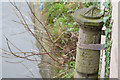
Boundary Post, Belfast
Old parliamentary boundary post overhanging the Loop River behind Ladas Drive in Belfast. See also Image
The inscription reads:
"Parliamentary
and Municipal Boundary of
Belfast
Ormeau Division
Ormeau Ward
1918".
Image: © Rossographer
Taken: 6 Dec 2018
0.22 miles