IMAGES TAKEN NEAR TO
Cregagh Road, BELFAST, BT6 9ET
Introduction
This page details the photographs taken nearby to Cregagh Road, BT6 9ET by members of the Geograph project.
The Geograph project started in 2005 with the aim of publishing, organising and preserving representative images for every square kilometre of Great Britain, Ireland and the Isle of Man.

There are currently over 7.5m images from over14,400 individuals and you can help contribute to the project by visiting https://www.geograph.org.uk
Image Map
Images are licensed for reuse under creativecommons.org/licenses/by-sa/2.0
Notes
- Clicking on the map will re-center to the selected point.
- The higher the marker number, the further away the image location is from the centre of the postcode.
Image Listing (22 Images Found)
Images are licensed for reuse under creativecommons.org/licenses/by-sa/2.0
Image
Details
Distance
1
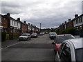
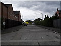
Mayfair Avenue, Cregagh
Mayfair Avenue is a busy street as it's often used as a shortcut between Montgomery Road and the Cregagh Road.
Image: © Dean Molyneaux
Taken: 9 Jul 2009
0.03 miles
2
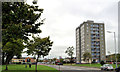
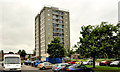
Willowbrook House, Belfast
See Image An eleven-storey block of flats, at Killagan Bend, in the Cregagh estate. Built (exact date unknown) in the 1950’s the block is one of three in the estate. This is the western side seen from Mount Merrion Avenue. Previously seen, 5½ years ago in Image
Image: © Albert Bridge
Taken: 10 Aug 2011
0.04 miles
3
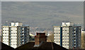
Tower blocks, Cregagh, Belfast (February 2016)
Woodstock House Image and Willowbrook House Image, two tower blocks in the Cregagh estate, seen, across conventional rooftops, from the higher ground on the Upper Knockbreda Road.
Image: © Albert Bridge
Taken: 22 Feb 2016
0.05 miles
4
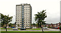
Woodstock House, Belfast (2)
See Image The northern side showing the block in its dominating position overlooking TPO Rippingham’s, redbrick, traditionally sized houses. Previously seen, 5½ years ago in Image See also Image
Image: © Albert Bridge
Taken: 10 Aug 2011
0.07 miles
5
Woodstock House, Belfast (1)
An eleven-storey block of flats, at Killagan Bend, in the Cregagh estate. Built (exact date unknown) in the 1950’s the block is one of three in the estate. This is the south/south western side. Previously seen, 5½ years ago in Image See also Image
Image: © Albert Bridge
Taken: 10 Aug 2011
0.07 miles
6
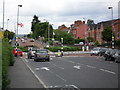
Bells Bridge, Cregagh Road
This is Bells Bridge Roundabout which was constructed in the 1940s in line with Ladas Drive and Mount Merrion Avenue - which at that time formed part of a ring road around the outside of the city. I presume at one point there was a bridge near here - as the Loop River passes nearby. This is also the municipal boundary between Belfast City and the Borough of Castlereagh.
Image: © Dean Molyneaux
Taken: 9 Jul 2009
0.07 miles
7
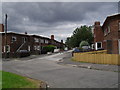
Burren Way, Cregagh Estate
This is the view down Burren Way on the Cregagh Estate. This street's claim to fame is that it was where soccer star George Best spent his childhood years. His family have recently sold the house.
Image: © Dean Molyneaux
Taken: 9 Jul 2009
0.08 miles
8
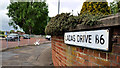
Ladas Drive sign, Belfast
An unusual sign, at the Cregagh Road end of Ladas Drive, beside the roundabout (middle left), which shows the old postal district number as “B6” rather than the standard “6”.
Image: © Albert Bridge
Taken: 24 May 2011
0.09 miles
9
Former access to Graham Gardens, Cregagh
Prior to the construction of Ladas Drive in the 1940s, this was the access to Graham Gardens from the Cregagh Road - opposite Onslow Parade. Furthermore I believe this may have been a bus terminus at one stage. Nowadays it's used frequently by driving schools as a place for practising manoeuvres. Indeed a driving school car can be seen parked on the left.
Image: © Dean Molyneaux
Taken: 9 Jul 2009
0.11 miles
10
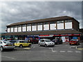
Greenway, Cregagh Road
This row of shops is known as Greenway, sited just off the Cregagh Road and at the main entrance to the estate.
Image: © Dean Molyneaux
Taken: 9 Jul 2009
0.14 miles