IMAGES TAKEN NEAR TO
Canton Court, BELFAST, BT6 9EL
Introduction
This page details the photographs taken nearby to Canton Court, BT6 9EL by members of the Geograph project.
The Geograph project started in 2005 with the aim of publishing, organising and preserving representative images for every square kilometre of Great Britain, Ireland and the Isle of Man.

There are currently over 7.5m images from over14,400 individuals and you can help contribute to the project by visiting https://www.geograph.org.uk
Image Map
Images are licensed for reuse under creativecommons.org/licenses/by-sa/2.0
Notes
- Clicking on the map will re-center to the selected point.
- The higher the marker number, the further away the image location is from the centre of the postcode.
Image Listing (148 Images Found)
Images are licensed for reuse under creativecommons.org/licenses/by-sa/2.0
Image
Details
Distance
1
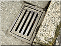
Matthew Swain grating cover, Belfast - April 2018(1)
A Matthew Swain gully grating cover at Willowfield Street. The first I’ve seen and, looking very similar to a Millfield product Image, I almost missed it.
There are very few internet references to this foundry at Newton Heath, Manchester. Some call it the “Railway Foundry” but a search for that name produces references to Mather & Platt Image and Image
The substantial factory may be seen here https://www.flickr.com/photos/clivehurst/32862214470/in/photolist-22xDZu1-S4VrsE-cJYmRQ-bypfFJ-9cEbHg-PEzsjE-BSD7Cd-Rncvh1-MNvCJ1-fFvDQ5-ZJFQgZ-W1pLLh-byEqtX-WgfCFR-b9w5F4-cJYdvW-rHCk9Z.
Image shows the inscription.
Image: © Albert Bridge
Taken: 13 Apr 2018
0.03 miles
2
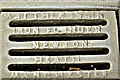
Matthew Swain grating cover, Belfast - April 2018(2)
See Image The inscription “Matthew Swain iron founder Newton Heath Manchester”.
Image: © Albert Bridge
Taken: 13 Apr 2018
0.03 miles
3
Nos 19&21 Castlereagh Road, Belfast (December 2017)
Nos 19 and 21 are currently vacant.
Image: © Albert Bridge
Taken: 7 Dec 2017
0.07 miles
4
Nos 1-21 Castlereagh Road, Belfast (4)
Now demolished pending redevelopment.
Image: © Albert Bridge
Taken: 7 Dec 2013
0.07 miles
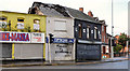
5
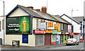
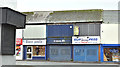
Shops, Castlereagh Road, Belfast
A block of shops, some occupied and some vacant, at the corner of Willowfield Street (left). The one with the “sold” sign was advertised as no 55.
Image: © Albert Bridge
Taken: 7 Dec 2013
0.07 miles
6
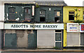
Nos 1-21 Castlereagh Road, Belfast (2)
The former “Abbots” home bakery.
Image: © Albert Bridge
Taken: 17 Oct 2012
0.08 miles
7
Nos 1-21 Castlereagh Road, Belfast (1)
The row seen from close to the end of the Beersbridge Road.
Image: © Albert Bridge
Taken: 17 Oct 2012
0.08 miles
8
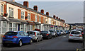
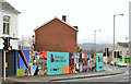
Jocelyn Avenue, Belfast
A late 19th century street, running from the Woodstock Road to Euston Street (background), still retaining the original houses.
Image: © Albert Bridge
Taken: 16 Nov 2011
0.08 miles
9
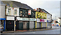
Nos 1-21 Castlereagh Road, Belfast (3)
Former bicycle shop and opticians. Completely forgotten what the one on the right was.
Image: © Albert Bridge
Taken: 17 Oct 2012
0.08 miles
10
Regeneration site, east Belfast (2)
A regeneration site, between Kenbaan Street and Clandeboye Street (right background).
Image: © Albert Bridge
Taken: 17 Oct 2012
0.08 miles