IMAGES TAKEN NEAR TO
The Silvergrove, Montgomery Road, BELFAST, BT6 9EG
Introduction
This page details the photographs taken nearby to The Silvergrove, Montgomery Road, BT6 9EG by members of the Geograph project.
The Geograph project started in 2005 with the aim of publishing, organising and preserving representative images for every square kilometre of Great Britain, Ireland and the Isle of Man.

There are currently over 7.5m images from over14,400 individuals and you can help contribute to the project by visiting https://www.geograph.org.uk
Image Map
Images are licensed for reuse under creativecommons.org/licenses/by-sa/2.0
Notes
- Clicking on the map will re-center to the selected point.
- The higher the marker number, the further away the image location is from the centre of the postcode.
Image Listing (8 Images Found)
Images are licensed for reuse under creativecommons.org/licenses/by-sa/2.0
Image
Details
Distance
1
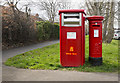
Postboxes, Belfast
Large postbox for franked mail (BT6 421) and George VI pillar box (BT6 719) on Montgomery Road, Belfast.
Image: © Rossographer
Taken: 20 Mar 2017
0.12 miles
2
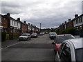
Mayfair Avenue, Cregagh
Mayfair Avenue is a busy street as it's often used as a shortcut between Montgomery Road and the Cregagh Road.
Image: © Dean Molyneaux
Taken: 9 Jul 2009
0.18 miles
3
Ladas Drive, Belfast
Street running from the Cregagh Road to the Castlereagh Road in east Belfast. Unusually for Belfast, most of the road surface is concrete.
Image: © Rossographer
Taken: 7 Jul 2010
0.22 miles
4
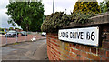
Ladas Drive sign, Belfast
An unusual sign, at the Cregagh Road end of Ladas Drive, beside the roundabout (middle left), which shows the old postal district number as “B6” rather than the standard “6”.
Image: © Albert Bridge
Taken: 24 May 2011
0.23 miles
5
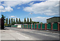
Bells Bridge, Cregagh Road
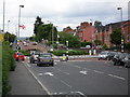
This is Bells Bridge Roundabout which was constructed in the 1940s in line with Ladas Drive and Mount Merrion Avenue - which at that time formed part of a ring road around the outside of the city. I presume at one point there was a bridge near here - as the Loop River passes nearby. This is also the municipal boundary between Belfast City and the Borough of Castlereagh.
Image: © Dean Molyneaux
Taken: 9 Jul 2009
0.24 miles
6
Telephone box, Cregagh Road, Belfast (January 2017)
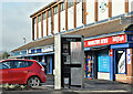
A KX300 telephone box, at these shops Image, on the Cregagh Road.
Image: © Albert Bridge
Taken: 9 Jan 2017
0.24 miles
7
Graham Gardens, Cregagh
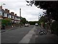
Graham Gardens sits just inside the city's municipal boundary and was constructed between 1936 and 1949. The long period can be explained by the effect of WWII - as numbers 17-23 are of a much more austere design. In the early 1990s, a mews development called "The Village Green" was constructed at the far end.
Image: © Dean Molyneaux
Taken: 9 Jul 2009
0.25 miles
8
Flush Bracket, Belfast
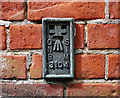
Flush bracket located on Cregagh Congregational Church on Graham Gardens off Ladas Drive in Belfast. The bracket is located on a brick wall close to the main entrance.
The number on the bracket is OSNIBM 3104.
The mark is 10.75 metres above MSL.
A flush bracket is a type of bench mark set onto the face of a building. See also http://www.geograph.org.uk/search.php?i=11037856 for many other examples I have found.
Image: © Rossographer
Taken: 7 Jul 2010
0.25 miles