IMAGES TAKEN NEAR TO
Caledon Road, AUGHNACLOY, BT69 6AL
Introduction
This page details the photographs taken nearby to Caledon Road, BT69 6AL by members of the Geograph project.
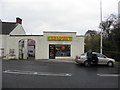
The Geograph project started in 2005 with the aim of publishing, organising and preserving representative images for every square kilometre of Great Britain, Ireland and the Isle of Man.

There are currently over 7.5m images from over14,400 individuals and you can help contribute to the project by visiting https://www.geograph.org.uk
Image Map
Images are licensed for reuse under creativecommons.org/licenses/by-sa/2.0
Notes
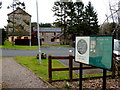
- Clicking on the map will re-center to the selected point.
- The higher the marker number, the further away the image location is from the centre of the postcode.
Image Listing (237 Images Found)
Images are licensed for reuse under creativecommons.org/licenses/by-sa/2.0
Image
Details
Distance
1
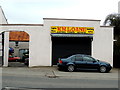
WM Loane, Aughnacloy
Pictured along Caledon Road
Image: © Kenneth Allen
Taken: 11 Apr 2018
0.01 miles
2
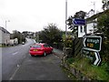
A28 Caledon Road, Aughnacloy
Heading south-east towards Armagh
Image: © Kenneth Allen
Taken: 8 Nov 2011
0.02 miles
3
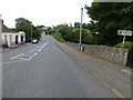
Caledon Road, Aughnacloy
Heading south-east
Image: © Kenneth Allen
Taken: 20 Aug 2014
0.02 miles
4
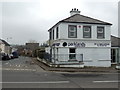
Parklands Veterinary Group, Aughnacloy
Pictured along Caledon Road
Image: © Kenneth Allen
Taken: 11 Apr 2018
0.02 miles
5
WM Loane, Aughnacloy
It is located along Caledon Road
Image: © Kenneth Allen
Taken: 8 Nov 2011
0.02 miles
6
Aughnacloy Caledon Street National School
The side view is looking south-east
Image: © Kenneth Allen
Taken: 8 Nov 2011
0.03 miles
7
Notice board, McCreedy's Mill
It includes the following text:
The McCrcedy Mill, Centre is a restoration of the old mill, buildings which were built in the early years of the 19th century. The mill was built to meet the needs of the growing agricultural industry and was operating as a cornmill in 1824.
By 1834 it was owned by John Falls and consisted of a cornmill, corn kiln, millers dwelling, stores and malt house with power supplied by water from a tributary of the Blackwater. The mill was built on the bank, of the river with the mill pond providing the head of water to drive the water wheel at all times of the year. The mill reflected the growth and prosperity of Aughnacloy as an important, market and staging post in the 19th century. The mill changed ownership frequently. One of the owners was Hugh Simpson who built Mill View, a fine residence with a gate lodge overlooking the mill.
In 1909 F A Montgomery Moore sold the mill to Hugh Treanor who continued to make use of the cornmill, but converted part of the building to a sawmill. He also used one of the buildings as a music hall which became a centre of entertainment for Aughnacloy society in the early years of the 20th century. The mill changed ownership again in 1919, when it was bought by Robert McCreedy who changed the use from corn milling to flax. He replaced water power by motor power and installed scutch machinery. 18 rims were in use, 16 for flax and 2 for tow, which was taken to Belfast Rope work. The demand for flax reached it's peak during the 2nd World War and the mill employed additional workers from Tyrone and Monaghan to cope with the demand for the war effort. This demand quickly disappeared after the end of the World War and the mill closed in 1952. It lay in a derelict state until 1998 when Aughnacloy Development Association purchased the site from the McCreedy family and undertook a programme of extensive renovations under local and international funding.
Image: © Kenneth Allen
Taken: 11 Apr 2018
0.03 miles
8
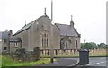
Aughnacloy Presbyterian Church
This church stands in Dungannon Road.
Image: © Eric Jones
Taken: 23 Jul 2012
0.03 miles
9
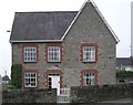
House at Aughnacloy
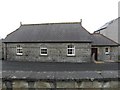
One of several stone walled dwellings in the town - this may have been a school at a time.
Image: © Kenneth Allen
Taken: 17 Oct 2006
0.03 miles
10
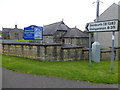
Presbyterian Church and former school
Pictured along the junction of Caledon Road and Armagh Road, Aughnacloy
Image: © Kenneth Allen
Taken: 20 Aug 2014
0.03 miles