IMAGES TAKEN NEAR TO
Ardenlee Street, BELFAST, BT6 8QJ
Introduction
This page details the photographs taken nearby to Ardenlee Street, BT6 8QJ by members of the Geograph project.
The Geograph project started in 2005 with the aim of publishing, organising and preserving representative images for every square kilometre of Great Britain, Ireland and the Isle of Man.

There are currently over 7.5m images from over14,400 individuals and you can help contribute to the project by visiting https://www.geograph.org.uk
Image Map
Images are licensed for reuse under creativecommons.org/licenses/by-sa/2.0
Notes
- Clicking on the map will re-center to the selected point.
- The higher the marker number, the further away the image location is from the centre of the postcode.
Image Listing (24 Images Found)
Images are licensed for reuse under creativecommons.org/licenses/by-sa/2.0
Image
Details
Distance
1
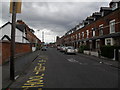
Dromore Street, Belfast
A street running from Earl Haig Gardens to the Cregagh Road (background). The 1908 street directory shows that it had a name but no houses. The 1910 edition had three houses and others in the course of erection. Previously seen in Image (July 2009). Shown as Earl Haig Gardens on the Google map.
Image: © Albert Bridge
Taken: 26 Apr 2012
0.05 miles
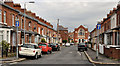
2
Dromore Street, Cregagh
This street - named after my own home town - runs along the side of Harding Memorial Primary School off the Cregagh Road.
Image: © Dean Molyneaux
Taken: 9 Jul 2009
0.11 miles
5
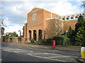
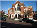
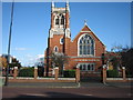
Martyrs Memorial Free Presbyterian Church
This Church was completed in 1969. Its Minister is Rev Ian Paisley.
Image: © Brian Shaw
Taken: 1 Nov 2005
0.13 miles
6
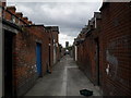
Entry between Dromore St and Reid St, Cregagh
This is the entry between the houses in Dromore Street and those in Reid Street, just off the Cregagh Road.
Image: © Dean Molyneaux
Taken: 9 Jul 2009
0.13 miles
7

Assembly election poster, Cregagh Road, Belfast (April 2016)
Near Ardenlee Avenue. Ulster Unionist Party.
Image: © Albert Bridge
Taken: 7 Apr 2016
0.14 miles
8
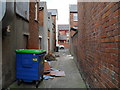
Rear of premises on Cregagh Road - at Reid Street
This is the entry along the back of premises on the Cregagh Road between Dromore Street and Reid Street.
Image: © Dean Molyneaux
Taken: 9 Jul 2009
0.15 miles
9
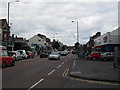
Cregagh Road at Gibson Park Gardens
This is the Cregagh Road at the junction of Gibson Park Gardens - or Daddy Winker's Lane. See: Image The Tesco on the right is remembered in my mind as being Stewart's.
Image: © Dean Molyneaux
Taken: 9 Jul 2009
0.15 miles
10
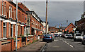
Titania Street, Belfast
A street, dating from around the end of the 19th century, running from Earl Haig Park to the Cregagh Road. Cregagh Methodist church Image is in the background. In common with most of the streets in the area, it has not been redeveloped and still retains the original terrace houses. Previously seen in Image (July 2009).
Image: © Albert Bridge
Taken: 26 Apr 2012
0.15 miles