IMAGES TAKEN NEAR TO
Delaware Street, BELFAST, BT6 8ET
Introduction
This page details the photographs taken nearby to Delaware Street, BT6 8ET by members of the Geograph project.
The Geograph project started in 2005 with the aim of publishing, organising and preserving representative images for every square kilometre of Great Britain, Ireland and the Isle of Man.

There are currently over 7.5m images from over14,400 individuals and you can help contribute to the project by visiting https://www.geograph.org.uk
Image Map
Images are licensed for reuse under creativecommons.org/licenses/by-sa/2.0
Notes
- Clicking on the map will re-center to the selected point.
- The higher the marker number, the further away the image location is from the centre of the postcode.
Image Listing (120 Images Found)
Images are licensed for reuse under creativecommons.org/licenses/by-sa/2.0
Image
Details
Distance
1
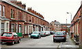
Rochester Street, Belfast (1)
An early 20th century street off the Ravenhill Road. This house Image is in the background. Image and Image show the name signs.
Image: © Albert Bridge
Taken: 22 Dec 2011
0.02 miles
2
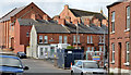
Vacant site, 36 Ravenhill Street, Belfast (June 2017)
A small vacant site, opposite Delaware Street. The following planning permission (28 April 2014) applies “Z/2013/1419/F Infill development of 2 no. townhouses & associated site works 36 Ravenhill Street Belfast BT6 8EP”.
Image: © Albert Bridge
Taken: 23 Jun 2017
0.03 miles
3
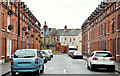
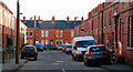
Delaware Street, Belfast
A street of terraces houses running from the Ravenhill Road to London Road. The 1901 street directory shows houses on the evens side only.
Image: © Albert Bridge
Taken: 12 Nov 2012
0.03 miles
4
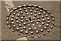
"BCC" manhole cover, Belfast (April 2014)
See Image Another of these enigmatic covers. This one is at the London Road end of Rochester Street. See also Image
Image: © Albert Bridge
Taken: 14 Apr 2014
0.03 miles
5
New apartments, London Road, Belfast (April 2014)
See Image (April 2011). The site, between Rochester Street and Delaware Street, is under redevelopment except that, at the time of my visit, the gates were closed and there was nobody present. Image shows the completed block.
Image: © Albert Bridge
Taken: 14 Apr 2014
0.03 miles
6
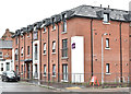
Apartments, 95 London Road, Belfast (June 2017)
See Image The completed block of social housing apartments (Choice Housing Association). Image shows the “before” view in April 2011.
Image: © Albert Bridge
Taken: 23 Jun 2017
0.03 miles
7
Toronto Street, Belfast (1)
A short street, dating from about the late 1890’s, running from the Ravenhill Road to Cappy Street Image (background). See also Image
Image: © Albert Bridge
Taken: 18 Jan 2011
0.04 miles
8
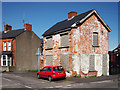
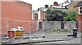
Derelict house, Belfast
A derelict house on the corner of London Road and Rochester Street in Belfast. The house was later demolished - see Image from April 2014.
Image: © Rossographer
Taken: 8 Apr 2011
0.04 miles
9
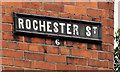
Rochester Street, Belfast (2)
The tiled name sign, with painted postal district number, at the Ravenhill Road end of Rochester Street Image (southern side).
Image: © Albert Bridge
Taken: 22 Dec 2011
0.04 miles
10
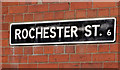
Rochester Street, Belfast (3)
The white on black name sign, incorporating the postal district number, at the Ravenhill Road end of Rochester Street Image (northern side).
Image: © Albert Bridge
Taken: 22 Dec 2011
0.04 miles