IMAGES TAKEN NEAR TO
Ravenhill Road, BELFAST, BT6 8EB
Introduction
This page details the photographs taken nearby to Ravenhill Road, BT6 8EB by members of the Geograph project.
The Geograph project started in 2005 with the aim of publishing, organising and preserving representative images for every square kilometre of Great Britain, Ireland and the Isle of Man.

There are currently over 7.5m images from over14,400 individuals and you can help contribute to the project by visiting https://www.geograph.org.uk
Image Map
Images are licensed for reuse under creativecommons.org/licenses/by-sa/2.0
Notes
- Clicking on the map will re-center to the selected point.
- The higher the marker number, the further away the image location is from the centre of the postcode.
Image Listing (310 Images Found)
Images are licensed for reuse under creativecommons.org/licenses/by-sa/2.0
Image
Details
Distance
1
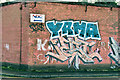
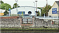
Substation graffiti, Belfast (January 2017)
Graffiti on a substation wall between the Ravenhill and Woodstock Roads. The street in now a cul-de-sac ending at business premises. With redevelopment and road widening more than 30 years ago it’s hard to identify the street’s original name but it might have been Myrtle Street. Today’s postal addresses for the nearby businesses is simply “Ravenhill Road”.
Image: © Albert Bridge
Taken: 15 Jan 2017
0.03 miles
2
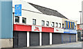
"Polita" supermarket, Ravenhill Road, Belfast (August 2018)
A Polita http://polita.co.uk/ Polish supermarket at 29 Ravenhill Road (closed on a Sunday morning). I have no connection with the business.
Image: © Albert Bridge
Taken: 5 Aug 2018
0.03 miles
3
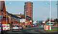
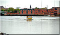
The Ravenhill Road, Belfast
The Ravenhill Road seems to have been laid out towards the end of the 19th century. It runs from the Ormeau Road at Rosetta to the Albert Bridge/Albertbridge Road (background). The tall redbrick building is Pottinger’s Quay Image
Image: © Albert Bridge
Taken: 20 Feb 2010
0.05 miles
4
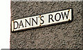
Dann's Row, Belfast (2)
See Image The street sign showing the spelling now in use.
Image: © Albert Bridge
Taken: 20 Feb 2010
0.06 miles
5
Bank, River Lagan, Ravenhill Road, Belfast - May 2016(1)
The remains of an old stone wall, on the bank of the River Lagan, close to the Ravenhill Road (background). The 1910 street directory shows McConnell's distillery and brewery on the inward side of Dann’s Row Image Further information about the site and wall very welcome.
Image: © Albert Bridge
Taken: 15 May 2016
0.06 miles
6
Amphibious bus, Belfast (3)
Image: © Albert Bridge
Taken: 9 May 2010
0.06 miles
7
Dann's Row, Belfast (1)
A narrow street off the Ravenhill Road – the original spelling was “Dan’s Row”. 100 years ago a gentleman by the name of William Haslett operated a grocery shop from premises on the left. The street once had 13 houses although it might have been a bit longer then. See also Image
Image: © Albert Bridge
Taken: 20 Feb 2010
0.07 miles
8
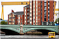
Amphibious bus, Belfast (8)
See Image Returning upstream having just passed under the Albert Bridge Image In the background are the Harland & Wolff cranes Image and Pottinger’s Quay apartments Image Continue to Image
Image: © Albert Bridge
Taken: 11 May 2010
0.07 miles
9
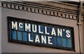
McMullan's Lane, Belfast (2)
The tiled sign at the Ravenhill Road end of McMullan’s Lane Image (northern side).
Image: © Albert Bridge
Taken: 18 Jan 2011
0.07 miles
10
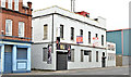
Nos 45-47 Ravenhill Road, Belfast (October 2015)
An occupied property, between McMullan’s Lane and Dann’s Row, offered for sale and described by the agent as “A multi purpose Investment Opportunity Extending to approximately 9500 sq ft”. This photograph appears a matter of record only. I have no connection with any of the parties involved in the sale. Image is on the left.
Image: © Albert Bridge
Taken: 25 Oct 2015
0.08 miles