
IMAGES TAKEN NEAR TO
My Ladys Road, BELFAST, BT6 8BZ
Introduction
This page details the photographs taken nearby to My Ladys Road, BT6 8BZ by members of the Geograph project.
The Geograph project started in 2005 with the aim of publishing, organising and preserving representative images for every square kilometre of Great Britain, Ireland and the Isle of Man.

There are currently over 7.5m images from over14,400 individuals and you can help contribute to the project by visiting https://www.geograph.org.uk
Image Map
Images are licensed for reuse under creativecommons.org/licenses/by-sa/2.0
Notes
- Clicking on the map will re-center to the selected point.
- The higher the marker number, the further away the image location is from the centre of the postcode.
Image Listing (131 Images Found)
Images are licensed for reuse under creativecommons.org/licenses/by-sa/2.0
Image
Details
Distance
1
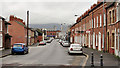
My Lady's Road, Belfast
A street where development seems to have started in the mid/late 1870’s. It runs from the Woodstock Road to the Ravenhill Road (background). The Ravenhill Road did not exist at the time. The area was (and still is) known as “The Lagan Village”. This view is from close to Lawnmount Street.
Image: © Albert Bridge
Taken: 22 Dec 2011
0.02 miles
2
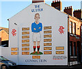
Rangers mural, Belfast
Part of a mural in Donard Street (corner of Ravenhill Street) listing the Ulstermen who played for (Glasgow) Rangers.
Image: © Albert Bridge
Taken: 18 Jan 2011
0.03 miles
3
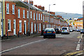
East Belfast
Looking down My Lady's Road towards the Ravenhill Road. It is a quite busy traffic route through east Belfast.
Image: © Robert Ashby
Taken: 8 Nov 2013
0.03 miles
4
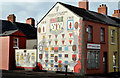
36th (Ulster) Division mural, Willowfield, Belfast (1)
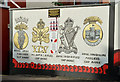
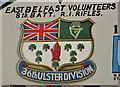
A mural, on the north western corner of Canada Street (left) and My Lady’s Road Image, depicting the badges of various units and regiments in which local people served during the First World War. Image and Image show detail from the mural.
Image: © Albert Bridge
Taken: 5 Nov 2013
0.05 miles
5
36th (Ulster) Division mural, Willowfield, Belfast (2)
See Image Detail showing the cap badges of four local regiments. There is also an inset depicting the nine who won the Victoria Cross. See also Image
Image: © Albert Bridge
Taken: 5 Nov 2013
0.05 miles
6
36th (Ulster) Division mural, Willowfield, Belfast (3)
See Image Detail showing what, for many, is a symbol of almost sacred standing http://en.wikipedia.org/wiki/Royal_Irish_Rifles.
Image: © Albert Bridge
Taken: 5 Nov 2013
0.05 miles
7
"The Untold Story" mural, Willowfield, Belfast
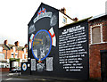
A mural, on the southern corner of Canada Street (foreground) and My Lady’s Road Image, recording gratitude for assistance, given by residents of Liverpool, following civil disturbances in the aftermath of the introduction of internment (detention without trial) in August 1971 http://cain.ulst.ac.uk/othelem/chron/ch71.htm#Aug and http://www.belfasttelegraph.co.uk/lifestyle/nostalgia/in-pictures-northern-ireland-troubles-1971-28691865.html. This photograph appears as a matter of neutral geographical and historical record only and does not express any political views of any kind.
Image: © Albert Bridge
Taken: 5 Nov 2013
0.06 miles
8
Edith Street, Inner East Belfast
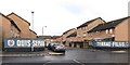
This is a cul-de-sac off Lord Street. Quis Separabit (Who will separate [us]?) is the motto of the Loyalist UDA (Ulster Defence Association) paramilitary force. Terrae Filius (son of the land) is the motto of the UYM (Ulster Young Militants) the youth wing of the Ulster Defence Association.
Image: © Eric Jones
Taken: 3 Nov 2014
0.06 miles
9
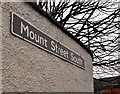
Mount Street South sign, Belfast
Unusual white on dark brown name sign at the My Lady’s Road end of Mount Street South.
Image: © Albert Bridge
Taken: 22 Dec 2011
0.06 miles
10
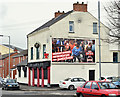
My Lady's Inn, Belfast (April 2016)
A Bluenose bar, on My Lady’s Road Image, at the corner of Mount Street. The 1901 street directory shows “Rea, Mrs., spirit grocer”.
Image: © Albert Bridge
Taken: 7 Apr 2016
0.07 miles