IMAGES TAKEN NEAR TO
Cherryville Street, BELFAST, BT6 8BJ
Introduction
This page details the photographs taken nearby to Cherryville Street, BT6 8BJ by members of the Geograph project.
The Geograph project started in 2005 with the aim of publishing, organising and preserving representative images for every square kilometre of Great Britain, Ireland and the Isle of Man.

There are currently over 7.5m images from over14,400 individuals and you can help contribute to the project by visiting https://www.geograph.org.uk
Image Map
Images are licensed for reuse under creativecommons.org/licenses/by-sa/2.0
Notes
- Clicking on the map will re-center to the selected point.
- The higher the marker number, the further away the image location is from the centre of the postcode.
Image Listing (162 Images Found)
Images are licensed for reuse under creativecommons.org/licenses/by-sa/2.0
Image
Details
Distance
1
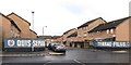
Edith Street, Inner East Belfast
This is a cul-de-sac off Lord Street. Quis Separabit (Who will separate [us]?) is the motto of the Loyalist UDA (Ulster Defence Association) paramilitary force. Terrae Filius (son of the land) is the motto of the UYM (Ulster Young Militants) the youth wing of the Ulster Defence Association.
Image: © Eric Jones
Taken: 3 Nov 2014
0.03 miles
2
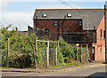
Vacant site, Cherryville Street, Belfast (April 2014)
A very long-term vacant site at the Woodstock Road end of Cherryville Street. Maymount Street Image is on the left.
Image: © Albert Bridge
Taken: 14 Apr 2014
0.05 miles
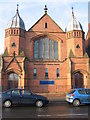
3
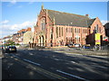
Ravenhill Presbyterian Church
Built 1905.
Image: © Brian Shaw
Taken: 1 Nov 2005
0.06 miles
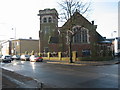
4
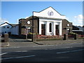
Ulster Temple Elim Church
One of a number of Churches on the Ravenhill Road, it was completed in 1931.
Image: © Brian Shaw
Taken: 1 Nov 2005
0.06 miles
5
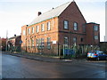
Cherryville Clinic
This houses a Speech & Language Therapy facility run by the City Council.
Image: © Brian Shaw
Taken: 21 Nov 2005
0.06 miles
8
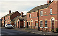
Maymount Street, Belfast
A late 19th century street, between the Woodstock Road and Cherryville Street. With the exception of the two on the left it still has the original terrace houses. The view is from Radnor Street Image
Image: © Albert Bridge
Taken: 16 Nov 2011
0.06 miles
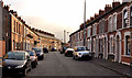
9
Emerald Street, Belfast (2)
See Image The north eastern side.
Image: © Albert Bridge
Taken: 5 Nov 2013
0.06 miles
10
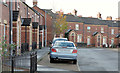
Emerald Street, Belfast (1)
The south western side of a street, running from Pearl Street (behind me) to Cherryville Street, built towards the end of the 19th century and now rebuilt on the same line. Image shows the other side.
Image: © Albert Bridge
Taken: 5 Nov 2013
0.06 miles