IMAGES TAKEN NEAR TO
Forge Manor, CRAIGAVON, BT67 0XP
Introduction
This page details the photographs taken nearby to Forge Manor, BT67 0XP by members of the Geograph project.
The Geograph project started in 2005 with the aim of publishing, organising and preserving representative images for every square kilometre of Great Britain, Ireland and the Isle of Man.

There are currently over 7.5m images from over14,400 individuals and you can help contribute to the project by visiting https://www.geograph.org.uk
Image Map
Images are licensed for reuse under creativecommons.org/licenses/by-sa/2.0
Notes
- Clicking on the map will re-center to the selected point.
- The higher the marker number, the further away the image location is from the centre of the postcode.
Image Listing (3 Images Found)
Images are licensed for reuse under creativecommons.org/licenses/by-sa/2.0
Image
Details
Distance
1
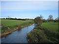
River Lagan looking downstream from Steps Bridge
Image: © Brian Shaw
Taken: 7 Nov 2005
0.16 miles
2
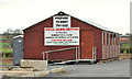
Gospel hall. Magheralin
Architecturally this hall, on the Steps Road, is in the modern style but built from traditional materials. Not to be confused with Image
Image: © Albert Bridge
Taken: 25 Feb 2012
0.17 miles
3
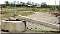
Unfinished development, Magheralin (1)
See Image (May 2007). The proposal to build 154 new houses between the Steps Road and the Lurgan Road never went beyond the spine road. This is the Steps Road end. See also Image
Image: © Albert Bridge
Taken: 25 Feb 2012
0.22 miles